


Search
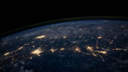
10 results for "Earth from Space"
 Earth from Space: Ouarzazate, Morocco (article)Energy Transition Earth from Space: Ouarzazate, Morocco In this week's edition of Earth from Space, courtesy of ESA, we look at a false-colour image ofhttps://www.geoversity.io/stories/812363/earth-from-space-ouarzazate-morocco/
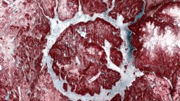 Earth from Space: Manicouagan crater (article)Natural Resources Management Earth from Space: Manicouagan crater For our first Earth from Space image of 2026, we look at an annular reservoir, made byhttps://www.geoversity.io/stories/746355/earth-from-space-manicouagan-crater/
 Earth from Space: The Danakil Depression (article)Remote Sensing Earth from Space: The Danakil Depression In this new edition of Earth from Space, we explore the unique geology and extreme environmenthttps://www.geoversity.io/stories/697718/earth-from-space-the-danakil-depression/
 Earth from Space: Snow-covered Amsterdam (article)Copyright: CC BY-SA 3.0 IGO Related articles Remote Sensing Earth from Space: Algerian arid landscape 4 min Remote Sensing Earth from Space: Quito’s volcanichttps://www.geoversity.io/stories/755180/earth-from-space-snow-covered-amsterdam/
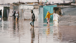
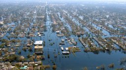
 Earth from Space: Flooding in Sri Lanka (article)Disaster Risk Earth from Space: Flooding in Sri Lanka In this edition of Earth from Space, we look at images showing the impact of flooding in Sri Lankahttps://www.geoversity.io/stories/755688/earth-from-space-flooding-in-sri-lanka/
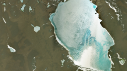
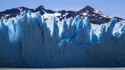
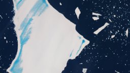 Earth from Space: The Fate of a Giant (article)Climate Change Earth from Space: The Fate of a Giant In this week's edition of Earth from Space, we look at the recent history of one of the world's largesthttps://www.geoversity.io/stories/770658/earth-from-space-the-fate-of-a-giant/
 Earth from space: Likouala-aux-Herbes river, Congo (article)Climate Change Earth from space: Likouala-aux-Herbes river, Congo In the first edition of Earth from Space, we learn about the importance of peatlandshttps://www.geoversity.io/stories/662224/earth-from-space-likouala-aux-herbes-river-congo/
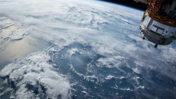
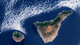 Earth from Space: Cloud patterns over the Canary Islands (article)Earth from Space: Cloud patterns over the Canary Islands In this week's Earth from Space from ESA, we look at the climatic factors that give rise to weatherhttps://www.geoversity.io/stories/904028/earth-from-space-cloud-patterns-over-the-canary-islands/
 Earth from Space: Rudong coast, China (article)Natural Resources Management Earth from Space: Rudong coast, China This week in Earth from Space, we look at a richly biodiverse area on the eastern coasthttps://www.geoversity.io/stories/781187/earth-from-space-rudong-coast-china/
 Earth from Space: Singing Dunes and Mysterious Lakes (article)Remote Sensing Earth from Space: Singing Dunes and Mysterious Lakes Next in our Earth from Space series, courtesy of ESA, we explore the singing duneshttps://www.geoversity.io/stories/722822/earth-from-space-singing-dunes-and-mysterious-lakes/
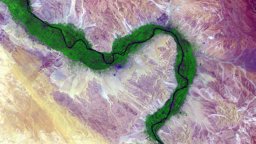 Can we measure river discharge from space? (article)from Space: Netherlands in bloom 4 min Remote Sensing Earth from Space: Kimberley, Australia 4 min Remote Sensing Earth from Space: Manicouagan craterhttps://www.geoversity.io/stories/1441185/can-we-measure-river-discharge-from-space/
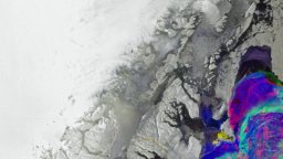 Earth from Space: Greenland's changing ice (article)Copyright: CC BY-SA 3.0 IGO Related articles Climate Change Earth from Space: Greenland's changing ice 4 min Climate Change Earth from Space: Jostedalsbreenhttps://www.geoversity.io/stories/922854/earth-from-space-greenlands-changing-ice/
 Earth from Space: Smoke Plumes from Chile Wildfires (article)Climate Change Earth from Space: Smoke Plumes from Chile Wildfires This week, we look at images captured by Copernicus Sentinel-3, showing clouds of smokehttps://www.geoversity.io/stories/770719/earth-from-space-smoke-plumes-from-chile-wildfires/
 Earth from Space: Pantanal (article)Copyright: CC BY-SA 3.0 IGO Related articles Natural Resources Management Earth from Space: Desert cropland 5 min Remote Sensing Earth from Space: Kimberleyhttps://www.geoversity.io/stories/807543/earth-from-space-pantanal/
 Earth from Space: Guinea-Bissau (article)Copyright: CC BY-SA 3.0 IGO Related articles Remote Sensing Earth from Space: Guinea-Bissau 4 min Natural Resources Management Earth from Space: Deserthttps://www.geoversity.io/stories/1036631/earth-from-space-guinea-bissau/
 Earth from Space: Olympic View (article)Copyright: CC BY-SA 3.0 IGO Related articles Remote Sensing Earth from Space: Algerian arid landscape 4 min Remote Sensing Earth from Space: Quito’s volcanichttps://www.geoversity.io/stories/798419/earth-from-space-olympic-view/
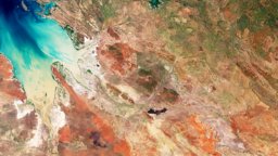 Earth from Space: Kimberley, Australia (article)Copyright: CC BY-SA 3.0 IGO Related articles Remote Sensing Earth from Space: Netherlands in bloom 4 min Remote Sensing Earth from Space: Kimberley, Australiahttps://www.geoversity.io/stories/869111/earth-from-space-kimberley-australia/
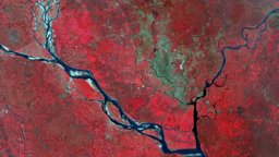 Earth from Space: Dhaka, Bangladesh (article)Copyright: CC BY-SA 3.0 IGO Related articles Remote Sensing Earth from Space: Algerian arid landscape 4 min Remote Sensing Earth from Space: Quito’s volcanichttps://www.geoversity.io/stories/839984/earth-from-space-dhaka-bangladesh/
 Earth from Space: Jostedalsbreen, Norway (article)Copyright: CC BY-SA 3.0 IGO Related articles Climate Change Earth from Space: Greenland's changing ice 4 min Climate Change Earth from Space: Jostedalsbreenhttps://www.geoversity.io/stories/860688/earth-from-space-jostedalsbreen-norway/
 Earth from Space: Desert cropland (article)Copyright: CC BY-SA 3.0 IGO Related articles Natural Resources Management Earth from Space: Desert cropland 5 min Natural Resources Management Earth fromhttps://www.geoversity.io/stories/994814/earth-from-space-desert-cropland/
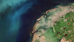 Earth from Space: Netherlands in bloom (article)Copyright: CC BY-SA 3.0 IGO Related articles Remote Sensing Earth from Space: Netherlands in bloom 4 min Remote Sensing Earth from Space: Kimberley, Australiahttps://www.geoversity.io/stories/922710/earth-from-space-netherlands-in-bloom/
 Earth from Space: Algerian arid landscape (article)Copyright: CC BY-SA 3.0 IGO Related articles Remote Sensing Earth from Space: Algerian arid landscape 4 min Remote Sensing Earth from Space: Quito’s volcanichttps://www.geoversity.io/stories/931124/earth-from-space-algerian-arid-landscape/
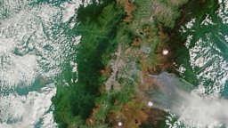 Earth from Space: Quito’s volcanic landscape (article)Copyright: CC BY-SA 3.0 IGO Related articles Remote Sensing Earth from Space: Algerian arid landscape 4 min Remote Sensing Earth from Space: Quito’s volcanichttps://www.geoversity.io/stories/922948/earth-from-space-quitos-volcanic-landscape/
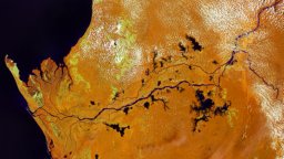 Earth from Space: Land of Rainforests (article)Copyright: CC BY-SA 3.0 IGO Related articles Remote Sensing Earth from Space: Land of Rainforests 4 min Remote Sensing Earth from Space: Kimberley, Australiahttps://www.geoversity.io/stories/900926/earth-from-space-land-of-rainforests/
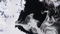 Earth from Space: Terra Nova Bay, Antarctica (article)Click the image below to enlarge or download it: Earth from Space, Terra Nova Bay, Antarctica Earth from Space, Terra Nova Bay, Antarctica Download imagehttps://www.geoversity.io/stories/827082/earth-from-space-terra-nova-bay-antarctica/
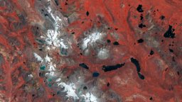 Earth from Space: Pariacaca Mountain Range, Peru (article)Check out the previous instalment of our Earth from Space series.https://www.geoversity.io/stories/734685/earth-from-space-pariacaca-mountain-range-peru/
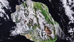 Earth from Space: Lava flow on Réunion Island (article)Disaster Risk Earth from Space: Lava flow on Réunion Island This week, we look at an active lava flow on the Piton de la Fournaise volcano on Réunion Islandhttps://www.geoversity.io/stories/880826/earth-from-space-lava-flow-on-reunion-island/
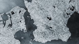 Earth from Space: Maritime highways in the Øresund Strait (article)Copyright: CC BY-SA 3.0 IGO Related articles Remote Sensing Earth from Space: Algerian arid landscape 4 min Remote Sensing Earth from Space: Maritime highwayshttps://www.geoversity.io/stories/853355/earth-from-space-maritime-highways-in-the-oresund-strait/
 Searching for Rare Earth Elements from space and how minerals made in the lab play a key role (article)And all this can be done from space!https://www.geoversity.io/stories/1754380/searching-for-rare-earth-elements-from-space-and-how-minerals-made-in-the-lab-play-a-key-role/
 Spatial autocorrelation and its importance in Earth observation (article)This can apply to either space or time, so there is spatial autocorrelation and temporal autocorrelation.https://www.geoversity.io/stories/1583489/spatial-autocorrelation-and-its-importance-in-earth-observation/
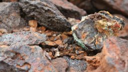 Five minerals that can help to save the planet from the carbon crisis (and natural kryptonite is one of them) (article)But where do these rare earth elements come from? The mineral that we use most to get of our rare earth elements from is bastnaesite.https://www.geoversity.io/stories/1342160/five-minerals-that-can-help-to-save-the-planet-from-the-carbon-crisis-and-natural-kryptonite-is-one-of-them/
 Earth ResourcesUAV Mapping Slums with UAVs 7 min Recent stories Remote Sensing Earth from Space: Guinea-Bissau 4 min Remote Sensing Earth from Space: Pariacaca Mountainhttps://www.geoversity.io/topics/earth-resources/
- Earth ObservationEarth from Space: The Fate of a Giant 4 min Remote Sensing Earth from Space: Flooding in Sri Lanka 3 min Remote Sensing Earth from Space: Snow-coveredhttps://www.geoversity.io/themes/earth-observation/
 How do satellites work? (article)from Space: Algerian arid landscape 4 min Remote Sensing Earth from Space: Quito’s volcanic landscape 4 min Remote Sensing Earth from Space: Netherlandshttps://www.geoversity.io/stories/1217917/how-do-satellites-work/
 Gaps In Optical Remote Sensing Datasets And How To Fix Them (video)from Space: Land of Rainforests 4 min Remote Sensing Earth from Space: Kimberley, Australia 4 min Remote Sensing Gaps In Optical Remote Sensing Datasetshttps://www.geoversity.io/stories/868875/gaps-in-optical-remote-sensing-datasets-and-how-to-fix-them/
- Earth Observation for Ecosystem Conservationis funded by the European Space Agency as one of the projects in the Pioneering Earth Observation Applications for the Environment (PEOPLE) series ofhttps://www.geoversity.io/courses/earth-obs-ecco/
 What is Critical Remote Sensing and why do we need it? (article)from Space: Algerian arid landscape 4 min Remote Sensing Earth from Space: Quito’s volcanic landscape 4 min Remote Sensing Earth from Space: Netherlandshttps://www.geoversity.io/stories/1852667/what-is-critical-remote-sensing-and-why-do-we-need-it/
- Earth Observation for Ecosystem Conservation IIOffered by PEOPLE-ECCO is funded by the European Space Agency as one of the projects in the Pioneering Earth Observation Applications for the Environmenthttps://www.geoversity.io/courses/earth-obs-ecco-2/
 How can we predict hazards caused by thawing permafrost? (article)from Space: Greenland's changing ice 4 min Climate Change The Social Impact of Climate Overshoot 3 min Climate Change Climate Risk in a World of Conflicthttps://www.geoversity.io/stories/663328/how-can-we-predict-hazards-caused-by-thawing-permafrost/
 12 challenges in protecting displaced people from flood risk (article)6 min Disaster Risk Earth from Space: Lava flow on Réunion Island 4 minSave articleRemove article TopicsDisaster Risk ThemesDisaster Resilience Sharehttps://www.geoversity.io/stories/470059/12-challenges-in-protecting-displaced-people-from-flood-risk/
 How many elephants? Ask a satellite (article)from Space: Land of Rainforests 4 min Remote Sensing Earth from Space: Kimberley, Australia 4 min Remote Sensing Gaps In Optical Remote Sensing Datasetshttps://www.geoversity.io/stories/1217918/how-many-elephants-ask-a-satellite/
 Why do you not see what I see? (article)from Space: Algerian arid landscape 4 min Remote Sensing Earth from Space: Quito’s volcanic landscape 4 min Remote Sensing Earth from Space: Netherlandshttps://www.geoversity.io/stories/1506859/why-do-you-not-see-what-i-see/
- GeoTechE: Geotechnology EthicsLearn from international scholars at the cutting edge of several disciplines, including critical data studies, ethics and geodata technologies.https://www.geoversity.io/courses/geotechnology-ethics/
 Mapping the Future: 6 Aspects of New Exploration Technologies for Critical Minerals Discovery (article)Elements from space and how minerals made in the lab play a key role 5 min Mineral Exploration Mapping the Future: 6 Aspects of New Exploration Technologieshttps://www.geoversity.io/stories/1489757/mapping-the-future-6-aspects-of-new-exploration-technologies-for-critical-minerals-discovery/
- Geo Web App building with OS toolsour team of GEO experts Contact team In this course you will learn how to design a web application for geospatial data dissemination, approaching it fromhttps://www.geoversity.io/courses/geo-web-app/
- Geo-informationHere’s What Works Personally and Professionally 6:04 Remote Sensing Earth from Space: The Danakil Depression 4 min Big Geodata What Satellites REALLY Knowhttps://www.geoversity.io/themes/geo-information/
 My profile5:46 Climate Change Earth from Space: Jostedalsbreen, Norway 4 min Remote Sensing Gaps In Optical Remote Sensing Datasets And How To Fix Them 3:20 Spatialhttps://www.geoversity.io/profile/
- Home PageKöbben, B.J. 41:39 Remote Sensing Earth from Space: Guinea-Bissau European Space Agency - ESA 4 min ITC Spatial Data Science Layman's Talk: Andhika Ariyantohttps://www.geoversity.io/
- Geological Remote Sensing for Mining & Explorationand 11 (Intel/AMD 64-bit) macOS 12 and 13 (Intel 64-bit and M-series*) Linux (Intel/AMD 64-bit, kernel 4.18.0 or higher and glibc 2.28 or higher) Disk spacehttps://www.geoversity.io/courses/grs/
 Colour composites unraveled (article)from Space: Algerian arid landscape 4 min Remote Sensing Earth from Space: Quito’s volcanic landscape 4 min Remote Sensing Earth from Space: Netherlandshttps://www.geoversity.io/stories/1824064/colour-composites-unraveled/
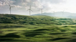
- Energy Transitionfrom Space: Maritime highways in the Øresund Strait 4 min Remote Sensing Earth from Space: Ouarzazate, Morocco 4 min Energy Transition The Hidden Riskhttps://www.geoversity.io/topics/energy-transition/
 Greenland’s unique underground potential for energy transitions and climate insights (article)Elements from space and how minerals made in the lab play a key role 5 min Mineral Exploration Mapping the Future: 6 Aspects of New Exploration Technologieshttps://www.geoversity.io/stories/155068/greenlands-unique-underground-potential-for-energy-transitions-and-climate-insights/
- Climate & EnergyM. 3 min Climate Change Climate Risk in a World of Conflict Kwakman, R. 6 min Climate Change Earth from Space: Jostedalsbreen, Norway European Space Agencyhttps://www.geoversity.io/themes/climate-energy/
- Water Resources6 min Remote Sensing Earth from Space: Kimberley, Australia 4 min Water Resources Earth from Space: Pantanal 4 min Natural Resources Management Earth fromhttps://www.geoversity.io/topics/water-resources/
- Remote SensingManagement Earth from Space: Desert cropland 5 min Remote Sensing Earth from Space: Quito’s volcanic landscape 4 min Climate Change Earth from Space:https://www.geoversity.io/topics/remote-sensing/
 Water, health and decisions: the impact of extreme weather (article)Water, health and inequality (e.g. variations in access to safe WASH in space and time, and among different population groups) 3.https://www.geoversity.io/stories/1582750/water-health-and-decisions-the-impact-of-extreme-weather/
- StoriesEuropean Space Agency - ESA 4 min Remote Sensing Earth from Space: Ouarzazate, Morocco In this week's edition of Earth from Space, courtesy of ESA, wehttps://www.geoversity.io/stories/
 How geodata-based insurance can help smallholder farmers cope with weather risks (article)It uses NDVI data from the Copernicus earth observation programme, which is shared through the EUMETCast delivery mechanism.https://www.geoversity.io/stories/46631/how-geodata-based-insurance-can-help-smallholder-farmers-cope-with-weather-risks/
- Climate Change: Jostedalsbreen, Norway 4 min Climate Change Earth from Space: Smoke Plumes from Chile Wildfires 3 min Climate Change Earth from Space: The Fate of ahttps://www.geoversity.io/topics/climate-change/
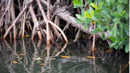 Five benefits of mangrove forests (article)from Space: Desert cropland 5 min Natural Resources Management Earth from Space: Rudong coast, China 3 min Natural Resources Management How a geo-informationhttps://www.geoversity.io/stories/1217911/five-benefits-of-mangrove-forests/
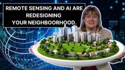 What Satellites REALLY Know About Your Backyard (video)Why are we making cities easier to read from space, and who decides if that’s a good thing?https://www.geoversity.io/stories/688471/what-satellites-really-know-about-your-backyard/
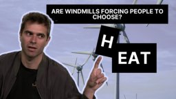 The Hidden Risk of the Energy Transition (video)Elements from space and how minerals made in the lab play a key role 5 minSave articleRemove article TopicsEnergy Transition Food Security ThemesResourcehttps://www.geoversity.io/stories/765496/the-hidden-risk-of-the-energy-transition/
 Satellites as Detectives (article)A novel method ASMs are difficult to map from space.https://www.geoversity.io/stories/566934/satellites-as-detectives/
 How NASA ARSET can get you started with satellite data (article)from Space: Algerian arid landscape 4 min Remote Sensing Earth from Space: Quito’s volcanic landscape 4 min Remote Sensing Earth from Space: Netherlandshttps://www.geoversity.io/stories/1871530/how-nasa-arset-can-get-you-started-with-satellite-data/
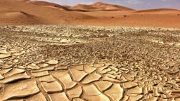 Using hyperspectral remote sensing to predict droughts (article)The response of vegetation to drought can be detected from space with satellite imagery.https://www.geoversity.io/stories/1217906/using-hyperspectral-remote-sensing-to-predict-droughts/
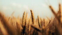 Remote Sensing to assess protein content in wheat - the secret to a perfect slice of bread (article)From the labs to space Measuring protein content in wheat grains is usually done in laboratories with a typical chemistry-based analysis.https://www.geoversity.io/stories/1217912/remote-sensing-to-assess-protein-content-in-wheat-the-secret-to-a-perfect-slice-of-bread/
- Mineral Exploration7 min Mineral Exploration Searching for Rare Earth Elements from space and how minerals made in the lab play a key role 5 min Mineral Exploration The evolutionhttps://www.geoversity.io/topics/mineral-exploration/
 How camera traps benefit Javan leopards (article)from Space: Desert cropland 5 min Natural Resources Management Earth from Space: Rudong coast, China 3 min Natural Resources Management How a geo-informationhttps://www.geoversity.io/stories/1853729/how-camera-traps-benefit-javan-leopards/
 Drought peril insurance for smallholder farmers (article)Population statistics VICI is based on long term timeseries of Normalised Difference Vegetation Index (NDVI) data from European Space Agency satelliteshttps://www.geoversity.io/stories/1462504/drought-peril-insurance-for-smallholder-farmers/
 Open spaces and why mapping them is crucial (article)Workflow To present a viable solution, the researchers developed a workflow that allows mapping from space, using satellite images to quantify the numberhttps://www.geoversity.io/stories/1546615/open-spaces-and-why-mapping-them-is-crucial/
- Natural Resources ManagementEarth from Space: Rudong coast, China 3 min Climate Change Earth from Space: Smoke Plumes from Chile Wildfires 3 min Artificial Intelligence Can Artificialhttps://www.geoversity.io/topics/natural-resources-management/
 Digital twins can make mapping easier and more accurate (article)Common methods for generating digital representations of the Earth's surface from Earth observation data originated in the 1960s.https://www.geoversity.io/stories/61719/digital-twins-can-make-mapping-easier-and-more-accurate/
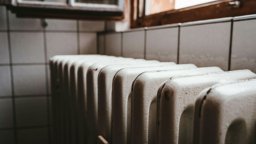 Heat or Eat? What to do when energy poverty strikes? (article)from Space: Greenland's changing ice 4 min Climate Change The Social Impact of Climate Overshoot 3 min Climate Change Heat or Eat?https://www.geoversity.io/stories/447792/heat-or-eat-what-to-do-when-energy-poverty-strikes/
 Enhancing Agricultural Monitoring with AI and satellite data: A Collaborative Training on Crop Type Mapping (article)I look forward to seeing the positive outcomes from this initiative and continuing to support similar efforts in the future.https://www.geoversity.io/stories/8895/enhancing-agricultural-monitoring-with-ai-and-satellite-data-a-collaborative-training-on-crop-type-mapping/
- Disaster Riskfrom Space: Flooding in Sri Lanka 3 min Remote Sensing Earth from Space: Pariacaca Mountain Range, Peru 3 min Climate Change How OpenStreetMap can helphttps://www.geoversity.io/topics/disaster-risk/
 The Energy Transition Explained (article)Elements from space and how minerals made in the lab play a key role 5 minSave articleRemove article TopicsEnergy Transition ThemesClimate & Energy Sharehttps://www.geoversity.io/stories/1347939/the-energy-transition-explained/
 The Art of Balancing Three Types of Satellite Resolution (video)from Space: Algerian arid landscape 4 min Remote Sensing Earth from Space: Quito’s volcanic landscape 4 min Remote Sensing Earth from Space: Netherlandshttps://www.geoversity.io/stories/824676/the-art-of-balancing-three-types-of-satellite-resolution/
 Geospatial data and the Sustainable Development Goals (article)Enumerated attributes deal with individual data within a predefined space (e.g., the population within a country).https://www.geoversity.io/stories/84647/geospatial-data-and-the-sustainable-development-goals/
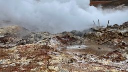 The evolution of geological remote sensing in mining and mineral exploration (article)This hyperspectral instrument observes Earth from outside the International Space Station.https://www.geoversity.io/stories/1499295/the-evolution-of-geological-remote-sensing-in-mining-and-mineral-exploration/
- Resource SecurityStart Here 3:14 Water Resources Earth from Space: Pantanal 4 min Natural Resources Management Earth from Space: Rudong coast, China 3 min Spatial Datahttps://www.geoversity.io/themes/resource-security/
- Disaster Resilience16:26 Climate Change Earth from Space: Smoke Plumes from Chile Wildfires 3 min Artificial Intelligence Deep Learning with Real-time Flood Inundation Mapshttps://www.geoversity.io/themes/disaster-resilience/
 Climate Change as a Global Challenge (article)from Space: Greenland's changing ice 4 min Climate Change The Social Impact of Climate Overshoot 3 min Climate Change Climate Risk in a World of Conflicthttps://www.geoversity.io/stories/1217923/climate-change-as-a-global-challenge/
 Supporting forest drought monitoring by developing ground-based sites (article)from Space: Netherlands in bloom 4 min Remote Sensing Earth from Space: Kimberley, Australia 4 min Remote Sensing Earth from Space: Manicouagan craterhttps://www.geoversity.io/stories/1435077/supporting-forest-drought-monitoring-by-developing-ground-based-sites/
 What is eDNA? (article)from Space: Desert cropland 5 min Natural Resources Management Earth from Space: Rudong coast, China 3 min Natural Resources Management How a geo-informationhttps://www.geoversity.io/stories/1217922/what-is-edna/
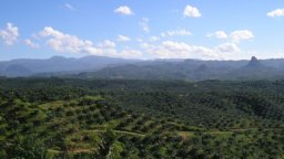 Enhancing Forest Management and Economic Assessment with Remote Sensing (article)from Space: Land of Rainforests 4 min Remote Sensing Earth from Space: Kimberley, Australia 4 min Remote Sensing Gaps In Optical Remote Sensing Datasetshttps://www.geoversity.io/stories/536141/enhancing-forest-management-and-economic-assessment-with-remote-sensing/
 What is overshoot day and why does it matter? (article)from Space: Greenland's changing ice 4 min Climate Change The Social Impact of Climate Overshoot 3 min Climate Change Climate Risk in a World of Conflicthttps://www.geoversity.io/stories/1338663/what-is-overshoot-day-and-why-does-it-matter/
 Why you can't just introduce your favourite animals anywhere! (video)from Space: Greenland's changing ice 4 min Climate Change The Social Impact of Climate Overshoot 3 min Climate Change Climate Risk in a World of Conflicthttps://www.geoversity.io/stories/1600269/why-you-cant-just-introduce-your-favourite-animals-anywhere/
 Coping with the most underestimated natural hazard (video)from Space: Smoke Plumes from Chile Wildfires 3 min Climate Change How OpenStreetMap can help humanitarians act early 7 minSave articleRemove articlehttps://www.geoversity.io/stories/1590575/coping-with-the-most-underestimated-natural-hazard/
 Where Dinosaurs lived: how geolocation supports palaeontological research (article)from Space: Desert cropland 5 min Natural Resources Management Earth from Space: Rudong coast, China 3 min Natural Resources Management Where Dinosaurshttps://www.geoversity.io/stories/71198/where-dinosaurs-lived-how-geolocation-supports-palaeontological-research/
 Climate Change: The uphill battle for species conservation (video)from Space: Smoke Plumes from Chile Wildfires 3 min Natural Resources Management The Research Revolution No One Taught You About 6:15 Climate Change Climatehttps://www.geoversity.io/stories/166847/climate-change-the-uphill-battle-for-species-conservation/
 The Social Impact of Climate Overshoot (podcast)from Space: Smoke Plumes from Chile Wildfires 3 min Natural Resources Management The Research Revolution No One Taught You About 6:15Save articleRemovehttps://www.geoversity.io/stories/912241/the-social-impact-of-climate-overshoot/
 Travelling back in time to understand the present and predict the future of our forests using remote sensing (article)from Space: Greenland's changing ice 4 min Climate Change Earth from Space: Jostedalsbreen, Norway 4 min Climate Change Travelling back in time to understandhttps://www.geoversity.io/stories/66338/travelling-back-in-time-to-understand-the-present-and-predict-the-future-of-our-forests-using-remote-sensing/
 How a geo-information app helps vegetable farmers to optimise inputs and boost productivity (article)from Space: Desert cropland 5 min Natural Resources Management Earth from Space: Rudong coast, China 3 min Natural Resources Management How a geo-informationhttps://www.geoversity.io/stories/129557/how-a-geo-information-app-helps-vegetable-farmers-to-optimise-inputs-and-boost-productivity/
 Rebuilding After an Earthquake in Nepal (podcast)6 min Disaster Risk Earth from Space: Lava flow on Réunion Island 4 minSave articleRemove article TopicsDisaster Risk ThemesDisaster Resilience Sharehttps://www.geoversity.io/stories/917274/rebuilding-after-an-earthquake-in-nepal/
 SAR Tomography: How to reveal the diverse world beneath the forest canopy (article)from Space: Pariacaca Mountain Range, Peru 3 min Remote Sensing SAR Tomography: How to reveal the diverse world beneath the forest canopy 3 minSave articleRemovehttps://www.geoversity.io/stories/1312451/sar-tomography-how-to-reveal-the-diverse-world-beneath-the-forest-canopy/
 Predicting floods in real time (article)6 min Disaster Risk Earth from Space: Lava flow on Réunion Island 4 minSave articleRemove article TopicsDisaster Risk Sharehttps://www.geoversity.io/stories/1400175/predicting-floods-in-real-time/
 What is geospatial auditing of public funds? (article)6 min Disaster Risk Earth from Space: Lava flow on Réunion Island 4 minSave articleRemove article TopicsDisaster Risk ThemesGeo-information Resource Securityhttps://www.geoversity.io/stories/1730019/what-is-geospatial-auditing-of-public-funds/
 How do LiDAR and radar Work? (article)from Space: Algerian arid landscape 4 min Remote Sensing Remote Sensing to assess protein content in wheat - the secret to a perfect slice of bread 4https://www.geoversity.io/stories/1217907/how-do-lidar-and-radar-work/
- ENVI Complete: 6-Course Training BundleIntel/AMD 64-bit) Other: Linux (Intel/AMD 64-bit, kernel 4.18.0 or higher and glibc 2.28 or higher) macOS 12, 13, and 14 (Intel 64-bit and M-series)Disk Spacehttps://www.geoversity.io/courses/envi-training/
 How does geological remote sensing make mineral exploration and mining more effective? (article)This hyperspectral instrument observes Earth from outside the International Space Station.https://www.geoversity.io/stories/148943/how-does-geological-remote-sensing-make-mineral-exploration-and-mining-more-effective/
- Hyperspectral Analysis of MineralsThis webinar is designed for analysts who need to move from raw imagery to a mission-ready briefing product in minutes.https://www.geoversity.io/courses/hyperspectral-minerals/
 Climate Risk in a World of Conflict (article)from Space: Greenland's changing ice 4 min Climate Change The Social Impact of Climate Overshoot 3 min Climate Change Climate Risk in a World of Conflicthttps://www.geoversity.io/stories/893392/climate-risk-in-a-world-of-conflict/
- ENVI FundamentalsFeature Extraction and Analysis: Techniques for identifying, classifying, and extracting specific features from imagery, including supervised and unsupervisedhttps://www.geoversity.io/courses/envi-fundamentals/
- Introduction to Spectral Remote SensingThe 10 modules are designed for entry-level analysts who want to focus on extracting information from spectral data for applications like vegetation andhttps://www.geoversity.io/courses/intro-remote-sensing/
 Why disasters highlight social inequality (article)from Space: Smoke Plumes from Chile Wildfires 3 min Climate Change How OpenStreetMap can help humanitarians act early 7 minSave articleRemove articlehttps://www.geoversity.io/stories/663465/why-disasters-highlight-social-inequality/
- Advanced ENVI for GEOINTSave courseRemove course TopicsDisaster Risk Remote Sensing ThemesGeo-information Earth Observation Climate & Energy Disaster Resilience Share Offeredhttps://www.geoversity.io/courses/advanced-envi-geoint/
- ENVI Basics for GEOINTSave courseRemove course TopicsDisaster Risk Remote Sensing ThemesGeo-information Earth Observation Climate & Energy Disaster Resilience Share Offeredhttps://www.geoversity.io/courses/envi-basics-geoint/
 How can games help us prepare for disasters? (article)6 min Remote Sensing Earth from Space: Pariacaca Mountain Range, Peru 3 minSave articleRemove article TopicsClimate Change Disaster Risk Urban Infrastructurehttps://www.geoversity.io/stories/879005/how-can-games-help-us-prepare-for-disasters/
 What is the Wet-Bulb Globe Temperature? (article)6 min Disaster Risk Earth from Space: Lava flow on Réunion Island 4 minSave articleRemove article TopicsDisaster Risk ThemesDisaster Resilience Sharehttps://www.geoversity.io/stories/1843229/what-is-the-wet-bulb-globe-temperature/
 Four popular sources of labelled data for machine learning (article)from Space: Algerian arid landscape 4 min Remote Sensing Gaps In Optical Remote Sensing Datasets And How To Fix Them 3:20 Artificial Intelligence Fourhttps://www.geoversity.io/stories/68467/four-popular-sources-of-labelled-data-for-machine-learning/
- SAR Essentials for GEOINTMaritime & Signatures: Automating ship detection from SAR imagery with optional AIS labelling.https://www.geoversity.io/courses/sar-geoint/
 How to Design Low-cost, Climate-adaptive Housing (article)from Space: Greenland's changing ice 4 min Climate Change The Social Impact of Climate Overshoot 3 min Climate Change How to Design Low-cost, Climate-adaptivehttps://www.geoversity.io/stories/653705/how-to-design-low-cost-climate-adaptive-housing/
 How OpenStreetMap can help humanitarians act early (article)from Space: Smoke Plumes from Chile Wildfires 3 min Climate Change How OpenStreetMap can help humanitarians act early 7 minSave articleRemove articlehttps://www.geoversity.io/stories/702101/how-openstreetmap-can-help-humanitarians-act-early/
 How do volcanoes trigger tsunamis? (article)6 min Disaster Risk Earth from Space: Lava flow on Réunion Island 4 minSave articleRemove article TopicsDisaster Risk ThemesDisaster Resilience Sharehttps://www.geoversity.io/stories/338880/how-do-volcanoes-trigger-tsunamis/
 Ethics and disaster management (article)6 min Disaster Risk Earth from Space: Lava flow on Réunion Island 4 minSave articleRemove article TopicsDisaster Risk ThemesDisaster Resilience Sharehttps://www.geoversity.io/stories/1872431/ethics-and-disaster-management/
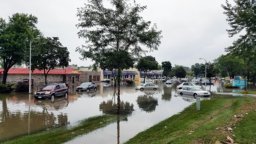 The power of impact-based weather forecasting (article)6 min Disaster Risk Earth from Space: Lava flow on Réunion Island 4 minSave articleRemove article TopicsDisaster Risk ThemesDisaster Resilience Sharehttps://www.geoversity.io/stories/1646135/the-power-of-impact-based-weather-forecasting/
 Fire hazard in informal settlements: should I stay or should I go? (article)6 min Disaster Risk Earth from Space: Lava flow on Réunion Island 4 minSave articleRemove article TopicsDisaster Risk ThemesDisaster Resilience Sharehttps://www.geoversity.io/stories/131362/fire-hazard-in-informal-settlements-should-i-stay-or-should-i-go/