Remote Sensing
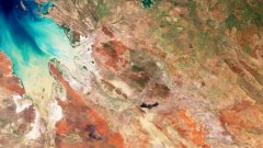
Earth from Space: Netherlands in bloom
4 min
Paul Vermunt’s mission is to advance the study of forest resilience to droughts. As a postdoctoral researcher in the Department of Water Resources in the ITC, Paul measures the dynamics of the water content in the forest with spatiotemporal tools. This, he believes, "can support decision-makers and researchers on forest and water management.”
Trees extract water from the soil and transport it to the canopy, where it replaces the water transpired through photosynthesis. If conditions are dry, this water supply can drop, leaving the trees more vulnerable to insect attacks, water stress mortality and forest fires. The past five years of summer droughts in Europe have exposed these kinds of vulnerabilities in the forest.
To monitor these situations, Paul aims to use microwave satellites that are sensitive to the water content in the trees. Unlike many other types of satellites, these instruments can observe the Earth’s surface regardless of cloud cover or the presence of sunlight, ensuring consistent time series. They can be of great value for monitoring the risk of drought-induced forest mortality.
However, one limitation on the development of satellite microwave products is the lack of ground observations.
In a quiet spot in Speulderbos, an area in the northwest region of the Dutch Veluwe, a 46-meter-high tower rises over a coniferous forest. Placed on and around this tower are numerous sensors, which are tested and used to measure fluxes in water content.
Experiments conducted by Paul and his ITC colleagues at this site represent the newest techniques to measure water content in different levels in the forest.
Some of the measurements taken include:
· hourly variations in local stem water content with frequency and time domain reflectometers.
· complete trunk water content with sap flow sensors.
· dew formation and interception of rain water droplets by the needles using dielectric leaf wetness sensors.
· canopy water content using the attenuation of received GNSS signals.
The aim for Paul and his colleagues is to develop a scalable, robust ground-based reference site for the calibration and validation of satellite-based microwave observations of tree water content.
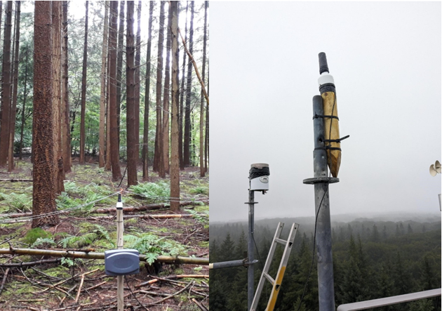
GNSS receiver antennas near the forest floor (left) and on top of the tower (right). (Photos: Paul Vermunt and Roelof Rietbroek)
An apt comparison is that of soil moisture products from microwave satellites. As Paul says, these greatly improved “as a result of networks of ground-based soil moisture observations, such as our own TWENTE soil moisture network, which includes twenty soil moisture stations in the region.” This and many other networks around the world are used to calibrate and validate satellite-based soil moisture products. And they are used as essential inputs for models and AI algorithms.
But why don’t these networks exist for tree water content?
An important explanation is the difficulty of the measurement. Unlike soil, trees are complex, dynamic, living organisms. While a soil moisture sensor can measure the same spot for a decade, this is much more difficult for a tree. The smaller constituents (branches, leaves and needles) are a particular challenge to measure. Moreover, trees have mechanisms to oppose sensors that disturb them.
All of this makes continuous measurements of tree water content challenging; hence why the destructive sampling of tree material is still a common way to collect this information.
As is true of all experimental fieldwork, things can go wrong. Many of the sensors require installations at the treetops at spectacular heights – something that Paul has a fear of. Luckily he has ITC colleagues on hand to assist with the installations (as well as a handy spider lift).
On the 5th of July 2023, storm Poly damaged some of the sensors in the tree tops. Fortunately, a month of valuable data with these sensors from a warm and dry period had already been collected. The other instruments survived the storm, and the data loggers have collected some promising observations.
Despite these minor obstacles, Paul is hopeful that he can find the best combination of sensors to support satellite products of forest water. And in the meantime, he says “I have the pleasure to work in a beautiful outdoor office.”
Support for project implementation and conducting experiments come from Paul’s colleagues at ITC, including Murat Ucer, Yijian Zeng, Bob Su, Roelof Rietbroek, Gabriel Parodi, Diana Chavarro Rincon and Christiaan van der Tol.
Paul Vermunt is a postdoctoral researcher funded by the ITC's Centre for Disaster Resilience (CDR) and hosted by the Department of Water Resources (WRS). Visit the webpage for CDR Postdoctoral Researchers here.
You can learn more about the Speulderbos research site on this page.
Login and start learning!