Remote Sensing
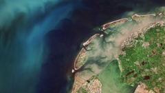
Earth from Space: Quito’s volcanic landscape
4 min
The Earth is orbited by many satellites, all looking at different positions on our planet from a great distance. In this article, we’ll talk about some of the different types of satellites there are, how they work, and some of the things we can do with satellite data.
There are different types of satellites, and the most widespread are geostationary and polar-orbiting satellites. The speed at which a satellite travels depends on the height of its orbit.
Geostationary satellites are 35,786 kilometres away from the Earth. They look at one position on the planet all the time by moving with the Earth as it turns.
Polar-orbiting satellites, on the other hand, revolve around the Earth in an orbit and, as the Earth turns, they pass over and scan different parts of its surface. Polar-orbiting satellites are between 200 and 1200 kilometres from the Earth. In contrast to geostationary satellites, many polar-orbiting satellites pass over the whole Earth in the course of one day. If they are located in a sun-synchronous orbit, they pass over each location at the same local time every day. This is useful if we want to, for example, examine changes or create a time series under more or less the same conditions.
The International Space Station, the largest artificial satellite, is rather closer, at about 400 kilometres. It is not in a sun-synchronous orbit and views parts of the Earth at different times of the day. Another important difference, obviously, is that there are people on board the ISS. Common satellites do not have people in them, which can be annoying when technical errors occur and there is nobody there to fix them.
Most satellites’ instruments detect radiation - from light waves to radio waves and beyond. Light waves are comparatively short and are observed by many different satellites. They can be used to look at the Earth. For instance, a satellite that looks very closely at the land cover enables us to take a time series of satellite pictures and see changes going on there.
Satellite data also contains information that the human eye cannot see. There are certain satellite instruments that, by measuring a very wide range of wavelengths, allow us to assess things like atmospheric composition – that is, to investigate what is in the atmosphere and in which quantities. To name an example, in my own research I have worked with ammonia. This is something we can see with satellite instruments by using a special algorithm that derives the ammonia concentration. It shows us the locations of ammonia sources, such as cattle farms, but also the directions in which ammonia is moving through the atmosphere.
There are many different colours of light. For Earth observation we can use visible light, which means light colours ranging from blue to red. Of these, blue has the shortest wavelength, while red has the longest. However, light colours beyond this range are useful as well. For instance, infrared light is beyond red in terms of wavelength, and the human eye cannot see it. An example of infrared light is thermal radiation.
One thing we can do with thermal radiation is determine the height of clouds. Clouds look white because they reflect visible radiation, which humans can see, and they emit thermal infrared radiation. This fact makes it possible to measure the temperature at the top of a cloud with a satellite instrument. If you then have a model which tells you which temperature is at what height, you can look at where the cloud is located and what its top height is. Feeding this information into weather models makes it possible to establish the type of cloud, which aids the forecast of rain and other weather types.
Besides clouds, satellites also allow us to look at things like water vapor in the atmosphere. Due to its particular properties, water plays a critical role in the distribution of energy around the globe. Because of their large-scale patterns, monitoring the amount of water vapor in the atmosphere can best be done using satellite instruments. Satellite information is therefore very interesting to meteorologists. The huge amounts of information available from satellites is partly responsible for the improved ability of weather models to make predictions.
Radio waves are within a wavelength range to which the atmosphere is mostly transparent, which is why we use it for radio communication. It is also the way that satellites communicate their information down to the Earth.
The information is first sent to data centres such as the European Organisation for the Exploitation of Meteorological Satellites (EUMETSAT), where a lot of calibrating and calculating is carried out and information is added, for example, about a satellite’s exact location and altitude at the time of measuring. This process results in large data sets which can then be downloaded by scientists and other interested parties for analysis and further processing. These parties will then use algorithms to add data about factors they are interested in – such as cloud cover, cloud heights or ammonia concentration – to turn the information they received into information they can really work with.
Satellite information comes down very quickly, but calibration on the Earth can take quite some time. Some institutes, like ITC, have a direct source of satellite data, namely: EUMETCast. This is a service offered by EUMETSAT that provides near-real-time data and products of a whole suite of satellite instruments. Lately we’ve seen a rise in near-real-time data that can be available within an hour. This is obviously good news for meteorologists, because the sooner they have the data they need, the sooner they can share their weather forecasts.
Login and start learning!