Remote Sensing
Earth from Space: Netherlands in bloom
4 min
A recent satellite mission called SWOT aims to drastically improve our river discharge monitoring capabilities from space
River discharge is the rate of flow of water across a river cross-section. It's important for human and ecological consumption, as well as an important indicator of the changing climate. As such, river discharge has been identified as an Essential Climate Variable (ECV). However, globally, river discharge is insufficiently measured. Installing and maintaining measuring stations on the ground can be expensive and logistically challenging. Further, when we think about certain locations, such as conflict zones, or remote regions, such as mountains or dense forests, it may be impractical to have such measuring stations on the ground.
Scientists have attempted to measure river discharge using several novel technologies, such as complex models, satellite technology, social media analytics, or a combination of all of these. Notably, satellite-based remote sensing has shown tremendous progress over recent years.
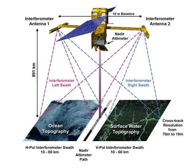
Figure 1. NASA/CNES SWOT mission (Image source: NASA https://swot.jpl.nasa.gov/resources/104/diagram-of-swot-data-collection/)
A recently launched satellite mission in December 2022, called the Surface Water and Ocean Topography (SWOT) mission, promises technological breakthrough in the measurement of river discharge from space. To approximate river discharge, it's sufficient to estimate river height, river width, and river slope. In the past, scientists used separate satellite imageries to estimate these different types of hydrological information, whereas the SWOT mission has the capability to estimate the river height, width, and slope from the same mission scene. This simultaneous measurement, along with the increased density of observations over time and space by SWOT (compared to previous satellites), is expected to improve our estimates of river discharge globally.
While space-based techniques provide us a near-global spatial coverage, the revisit time of the satellite observations at each location may not be sufficient for some hydrological applications. This is because satellite information (from SWOT or other altimetry satellites) gives us river discharge estimates for a section once every few days. This can limit satellite missions’ application in use cases, such as, the estimation of daily river discharge, or the prediction of flash floods, etc.
Similarly, satellite data faces a challenge of latency – meaning, there is a delay between when the data is observed and when the data is available for the end-user. This is because satellites collect large amounts of data that has to be processed before it can be used by river modelers. The latency further limits the operational use of space technology for use cases, such as flash flood response.
Nonetheless, it’s important to remember that the number of measurement stations on the ground is limited, particularly when we think about the developing regions of the world. Space technology thus allows us to observe rivers that have never been measured before – how exciting is that?
At ITC, we are studying the application of altimetry and SWOT technologies to monitor the world’s river discharge and lake volume changes – with a focus on the North Sea and the Horn of Africa region. To know more about the project, click here to see the project page.
External resources:
NASA SWOT page: https://swot.jpl.nasa.gov/
CNES SWOT page: https://swot.cnes.fr/en/SWOT
Login and start learning!