Mineral Exploration
Unlocking Earth's Superhot Energy for green and sustainable power generation
3 min
At ITC, we use hyperspectral imaging to detect, map and study hydrothermal systems. These systems are of prime importance because of their association with ore deposits, geothermal resources and the earliest life forms on Earth.
We have mapped and linked the hydrothermal alteration minerals (formed by the interaction of rock and fluids) to previously mapped alteration systems using airborne hyperspectral imagery at the Rodalquilar alunite-gold deposit in Southeast Spain. The Rodalquilar alunite-gold deposit formed in the Miocene volcanic caldera complex and the economically most important Au ores are associated with high-sulfidation mineral assemblages, including alunite, kaolinite and illite. These three alteration minerals are good indicators for Au mineralization at Rodalquilar.
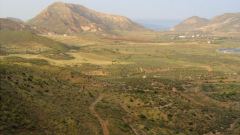
Take a look at the four images below. The photo on the upper left was taken from the margin of the mineralized caldera crater at Rodalquilar, viewing towards the east. You can see a broad valley formed by a stream flanked by mountains draining towards the Playazo de Rodalquilar into the Mediterranean Sea.
The same area is shown in the image in the upper right, constructed by draping an aerial hyperspectral image that simulates natural colours over an elevation image. Although the various topographic features are visible, the rock outcrops are all shown in shades of grey and brown, and the alteration minerals cannot be observed easily. This changes when using an enhanced infrared hyperspectral image.
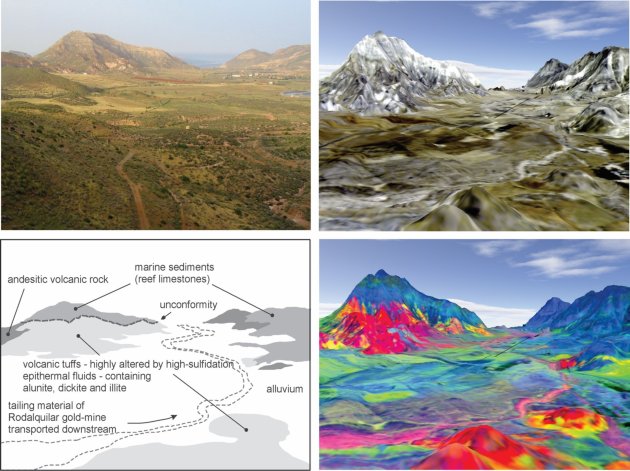
The infrared hyperspectral image in the lower right unveils the alteration minerals in this area. The image is composed of three band ratios that target the absorption features of these minerals. The band ratios show alunite, kaolinite and illite in magenta, red, yellow and green colours. High-intensity alteration zones become visible in magenta and red; less intensely altered rocks appear in yellow to green colours. The pinkish colours in the stream bed are alteration minerals transported downstream from the main mining area towards the Playazo. The blue-coloured mountains flanking the valley consist of limestone deposits that overly the alteration system in the left of the image. The geological sketch on the lower left summarizes the important features of the area.
These images exemplify the strength of infrared hyperspectral imagery and show how hyperspectral methods can help unveil geology that is not visible to the naked eye. Hyperspectral images specifically facilitate studies where hydrothermal alteration plays a significant role. Imagine the possibility of exploring geology on foot while carrying a camera that shows these infrared bands in real-time. It will be easy to spot mineralized areas, even from a distance, and make mineral exploration more efficient.
Interested in learning more? Check out this course on Geological Remote Sensing for Mining and Exploration from Geoversity.
Login and start learning!