Artificial Intelligence
Monitoring urban forests using deep learning
6 min
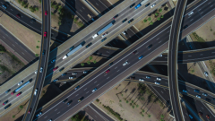
Resilient roads keep our society and economy going, but taking care of them is getting tougher because of climate change, old infrastructure, and more traffic. Fixing them up costs a lot, especially since many are already past their prime. Monitoring how they're doing is super important to understand the health of infrastructures and where repairs are needed, but lots of countries are putting it off. Recent disasters showed how bad things can get when we neglect our roads. We need better, automatic ways to check on them to keep everyone safe, whether it's just another day or an emergency.
In this brainsnack, we’ll preview some of the research into UAVs and monitoring of road infrastructure.
Unmanned Aerial Vehicles (UAVs, aka drones) combined with artificial intelligence can play an important part in monitoring road infrastructure. However, consumer-grade drones aren’t equipped for monitoring complex scenes and analysing them in real-time. To tackle this problem, researchers set out to develop an innovative UAV system that incorporates edge computation and remote processing.
The system was validated by carrying out a trial on a highway in Guadalajara, Spain. The results showed that the system is able to adequately support road operators on the ground in real-time. As the system is dynamic, it can be extended with additional modules and updated as technology progresses.
In a related study, researchers investigated how UAVs could be used to estimate the speed at which traffic is moving. This information is crucial for managing traffic flow and enforcing speed limits. Using drones for this purpose could be a cost-effective alternative to traditional methods such as radar, lasers, and video systems.
However, UAV-embedded devices tend to have a hard time processing the information produced by traditional methods. To address this, the researchers propose a method that replaces the detection of isolated road objects with segmentation of the complete scene. In this new method, vehicle speed is estimated from recognizing the shape of the cars in the segmented scene.
If you’re interested to know more about the research involving UAVs, you can read the full papers.
Click here to read the journal article 'Towards Improved Unmanned Aerial Vehicle Edge Intelligence: A Road Infrastructure Monitoring Case Study'
Click here to read the journal article 'Vehicle tracking and speed estimation from unmanned aerial vehicles using segmentation-initialised trackers'
Login and start learning!