UAV
UAVs for Rubber Plantation Monitoring in India: A Tailored Training at ITC
7 min
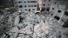
In February 2023, a powerful earthquake with a magnitude of 7.8 hit southern and central Turkey, as well as northern and western Syria. It caused extensive damage across an area of about 350,000 square kilometres. The confirmed death toll was 59,259, with 50,783 in Turkey and 8,476 in Syria. Approximately 14 million people were affected, and around 1.5 million people were left without homes.
The disaster was exacerbated by damaged roads and winter storms. Significant areas were reduced to rubble and communications were disrupted. All of these issues hindered response efforts, increasing the loss and suffering of the people affected.
While Unmanned Aerial Vehicles (UAVs) were used for filming and documentation, they were not deployed systematically and to their full potential. If they had been, it’s probable that rescue operations could have been significantly faster, and the casualty rate much lower.
In this article we’ll list several of the ways that UAVs can be useful in disaster resilience.
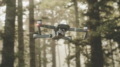
UAVs, commonly known as drones, are flexible and cost-effective instruments for responding to disasters, monitoring environmental conditions and assessing the state of critical infrastructure. They therefore play a key role in enhancing resilience in many sectors, including, for example, emergency services, provision of water supplies, and transportation networks.
In the case of disasters, UAVs offer a rapid and efficient means of surveying the affected areas. With advanced sensors and communication tools, they deliver real-time and immediate information on the local situation to emergency responders. This information empowers us to identify hazards, assess damage, and locate survivors in hard-to-reach places.
Remote sensing
For remote sensing, UAVs can be equipped with various sensors such as imaging cameras, temperature-detecting thermal cameras, smoke detectors, Ground Penetration Radars (GPRs), and gas detectors. These sensors can gather the data needed to ensure that information is accurate and support the making of critical decisions before, during, and after a disaster event.
Monitoring changes
UAVs can provide data and information needed to monitor changes in environmental conditions and study potential threats such as flooding, gas emissions, or landslides. In these situations, they provide timely data for early warning systems, enabling communities to prepare for and mitigate the impact of impending disasters.
UAVs can also help to identify vulnerable areas such as floodplains and wildfire-prone zones, assess potential risks, and develop strategies such as barrier construction and vegetation management to enhance community resilience.
Maps and 3D Models
UAVs can provide detailed and high-resolution data such as maps and 3D models. This 'geospatial' information provides data on a location that then supports decisions for strengthening resilience to and managing disasters.
Carrying equipment
UAVs can also be equipped with life-saving equipment and carry them autonomously to places that are unreachable by other means. This is a vital step forward in providing immediate emergency responses even faster than helicopters and when flights aren’t possible
Rapid Survey for Coordinate Response
UAVs can also make rapid surveys over disaster-affected areas using high-resolution imagery. They play a complementary role to other sources of data such as satellite images and field surveys of specific locations. This allows the large-scale damage to be assessed and mapped, which, in turn, helps emergency responders to prioritize their efforts and improve the allocation of resources.
Locating survivors
Thermal cameras mounted on UAVs can also assist in locating survivors in hard-to-reach or dangerous locations. They enhance the speed and efficiency of search and rescue missions, especially in situations where traditional approaches may be limited, labour intenstive and/or time-sensitive.
Moreover, UAVs can be equipped with video cameras and real-time communication solutions that provide aerial views of disaster scenes. This aerial perspective helps decision-makers to understand the dimension of the disaster and coordinate the response efforts more efficiently.
Inspecting Infrastructure
In a post-disaster situation, UAVs can inspect critical infrastructure like bridges, power lines, and pipelines. They provide quick and thorough assessments of structural integrity, which is the ability of a structure to hold together under a load. This helps in deciding which repairs need to be made and the planning of restoration efforts. With UAVs, we can also monitor the progress and efficiency of the reconstruction process.
UAVs can often replace satellite imagery by providing better spatial resolution and more flexible aerial imagery, and by contributing to emergency response with safer and less labour-intensive solutions. So rather than replacing the traditional solutions, such as mobilizing rescue services through field campaigns, they are evolving into a means of responding to disasters that’s more flexible than others.
Login and start learning!