Digital Twins
How can digital twins help us to build sustainable cities?
2 min
Although modern cities are extremely complex and dynamic systems, Digital twins have been successfully built and implemented for various applications.
Sustainable city planning and development is increasingly aided by digital twins (DTs). Although modern cities are extremely complex and dynamic systems, DTs have been successfully built and implemented for various applications. In this article we’ll present three successful examples.
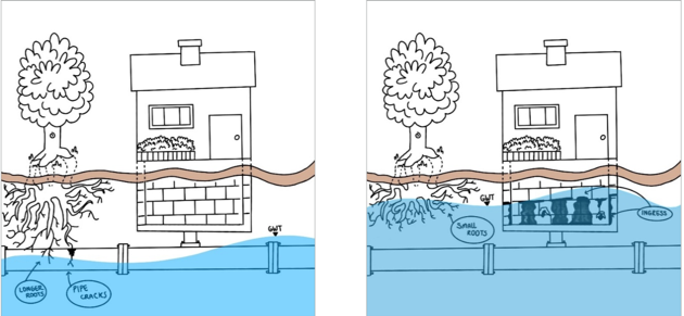
Managing groundwater in cities is becoming ever more complicated. In this time of climate change, we are faced with more frequent and intense periods of drought and rain. As a result, groundwater levels drastically fluctuate, and these fluctuations can lead to waterlogging and flooded buildings.
Heavy rainfall can lead to shallow tree roots and basement water ingress, causing damage and flood risks. Conversely, low rainfall can cause the water table (GWT) to drop, affecting vegetation and underground structures (see figure 1). Balancing these challenges is crucial for effective groundwater management in urban areas.

Figure 1: The impacts of heavy vs. low rainfall
Capacities of traditional groundwater control pumps are often insufficient to suit extreme conditions. That’s why a DT model was developed as part of a supplementary solution. Based on a 3D game development platform called Unity, the DT model incorporates real-time GWT data from 273 sensors distributed across the city (available from the public ‘Twents Waternet’ website).
The solution integrates real-time data, prediction models and connectivity with pumping machines in a 3D photorealistic city model to support dynamic GWT control. An algorithm has been developed to predict the groundwater level based on rainfall data. It uses the GWT level with a combination of IoT protocols as triggers in the game engine to de/activate a water pump in the physical world. The model also includes additional features such as:
On the whole, this solution provides an interactive visualization of the GWT and aids the decision-makers by identifying areas that require automated water pump drainage. The associated research contributes to the development of an integrated and effective groundwater management and control system and facilitates sustainable water management practices in urban areas.
Many modern cities and city dwellers are impacted by climate change and the ‘urban heat island’ effect. It’s a phenomenon that has raised questions about the boundaries of thermal comfort. The physiological equivalent temperature (PET) can be very helpful in making accurate assessments here. It allows to quantify the combined effects of air temperature, humidity, wind speed and solar radiation on human perception of thermal conditions.
There used to be an abundance of different heat maps produced by various agencies all using their own metrics and methods. To standardize, a unified methodology was developed using PET as a metric for heat stress. By integrating multiple environmental variables, PET empowers urban planners, architects and environmental scientists to design spaces that prioritize human comfort and health. In this context, a DT-based model for PET calculation has been developed to identify the effect of adding (or removing) trees, buildings, water bodies, green areas or buildings.
By combining empirical meteorological and GIS data, the DT model offers a cost-effective and practical approach to generating heat maps. It allows for the estimation of urban air temperatures and wind speeds using routine weather observations and information about land use and building geometries.
Practically, the model enables urban planners and decision-makers to identify impactful changes without the need to invest in untested solutions. Resources no longer need to be committed without knowing what the expected outcome will be. The model’s ultimate goal is to reduce temperatures in key urban areas.
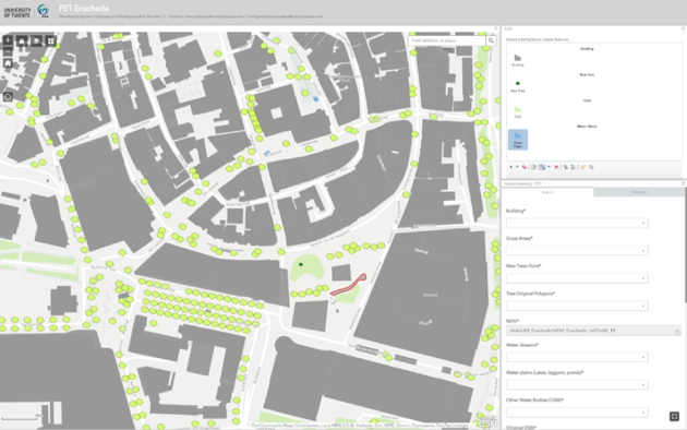
The potential for the DT for PET calculation to support collaborative and multidisciplinary street planning, evidence-based policies and enhanced citizen climate awareness has been demonstrated in the Dutch city of Enschede (see figure 2).

Figure 2: Digital twin for PET calculation as developed in Enschede (the Netherlands)
Every year, humanity produces over two billion metric tons of solid waste. Municipalities in countries across the globe are grappling with the challenge of managing these massive amounts, often with limited collection services. Pretoria in South Africa is no exception.
To mitigate waste management issues in Pretoria, a special digital twin prototype has been developed. It features stakeholder prioritization, citizen participation for locating waste sites, waste generation simulations, waste-collection route optimization and a control dashboard. The model integrates real-time monitoring, optimized collection routes and citizen engagement via the open-source tool Epicollect5.
A three-day data collection effort uncovered 1,270 containers and 820 littering sites, revealing distribution gaps – particularly in parks. Litter in park areas emphasizes the importance of providing well-distributed containers and prompt maintenance. Photos aid issue identification, while citizen engagement improves accuracy and efficiency. Waste generation simulations provide insights into flows and optimal container locations, aimed at reducing fuel use and emissions (see figure 3).
Waste generation simulations provide information about waste flows, low-capacity areas and optimal container locations. Optimized collection routes are proposed to reduce fuel use and emissions. A control dashboard has been developed which includes stakeholders’ system requirements and displays 11 indicators on three maps.
This prototype lays the foundation for waste management digital twinning that is scalable to different areas, vehicles and production levels.
In this article we’ve described three ways that digital twins have been successfully implemented. To learn more about what is required to create a Digital Twin – as well as some of the challenges, then see our article on Building a city digital twin – needs and challenges