Digital Twins
Cities are Cloned in the Virtual World to Transform Urban Planning
4 min
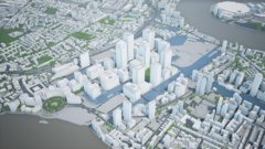
Digital Twins are digital representations of physical reality. They can have many forms and scales, from compact models in Mechanical Engineering to complete digital city models. Digital twins are very useful for visualizing the current state of a city but can also be used to simulate future or past events.
The production of content for Digital Twins at the city scale presents several interesting challenges. After all, for a Digital Twin, we need an input that represents the living city in a digital model. Therefore we need to make or make use of existing information on what the city looks like. This can be based on cadastral maps. Often, these are 2D maps which need to be converted to 3D to give a realistic representation of the city. Traffic and other dynamic objects need to be modelled and integrated with the static 3D geo information.
At ITC, we focus on several aspects of the creation of digital twins. Which sensors can best be used to capture the environment? How and when should the measurements be done? When we have the data, how do we process that automatically? Can we make use of existing algorithms, or do we need to develop new ones based on the data or the user requirements? In short, we deal with all the challenges related to producing Digital Twins from Earth Observation data.
Login and start learning!