UAV
UAVs for Rubber Plantation Monitoring in India: A Tailored Training at ITC
7 min
When mapping forests and plantations, scientists find many advantages in the use of drone technology. Learn about some of those advantages in this article
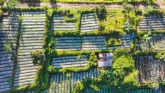
In order to get an estimation of the dimensions of a forest, researchers in the past had to step into dense forests and meticulously measure the canopy size and height of the trees armed only with tape measures and a clinometer - an instrument used for measuring slopes.
Later, researchers started to utilise planes and satellites, which eased the mapping process. However, the spatial resolution they provided often fell short of in-depth analysis, especially when scrutinizing individual trees.
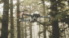
In the present day, drones equipped with miniaturized sensors have become a staple in environmental mapping, allowing for a more efficient mapping process and a better spatial resolution than any other method. In this article, we’ll discover how drones are being used to map large plantations and forests.
Researchers fly the drones over the plantations or forests to acquire data and potentially create a 3D representation of the trees. This is called a “3D point cloud”. With this point cloud, they can extract the height and volume of the canopies and other parameters like the forest density, estimate the age of the forest, and even how many trees there are.
Not only the spatial shape of the canopies are of interest, but also their temperature and how they reflect the light spectrum. Drone cameras have bandpass filters that let only a small bandwidth of light (red, for example) reach the sensor, to assess the spectral response of the elements in the picture – such as trees. With either multispectral or hyperspectral remote sensing (two different forms of collecting spectral data), researchers can use the spectral information to identify species based on their spectral properties. With this they can assess things like plant health; a healthy plant will absorb red light and reflect near-infrared light.
Lastly, scientists can assess the canopy temperatures with a thermal camera, which is also attached to the drone. Trees with enough water transpire through their leaves, which has a cooling effect. Assessing the temperature of the trees provides valuable information to plantation farmers or foresters, such as possible water stress caused by droughts. As a rule of thumb, trees that are colder than the surrounding air temperature have enough water, while trees that are as warm or warmer than the surrounding air often lack water.
One of the advantages of drones is that you can deploy them when you need them. For example, during a hot day, the plants are not so water-stressed in the morning but might have become so by the afternoon, having used up all the available water in the soil. Satellite usually have an “overpass time" - that is, they come back at the same time frame during certain periods. If a satellite therefore only collects data at 12:00 every morning, researchers lack information about soil moisture during other times of the day. Additionally, if there is cloud cover at that time, the data for that day might be ruined. Drones are much more flexible in this respect, and can overcome some of the obstacles faced by satellites.
Being closer to the surface, drones also have a much higher resolution than satellites and other techniques. Satellites can capture a resolution of a few meters, while drones usually capture a pixel resolution of a few millimeters. That kind of data is vital to identifying patterns in tree leaves that can provide information about the health of the trees.
The main disadvantage of drones is their range. For example, drones can’t be used for managing large forest reserves of several square kilometres. Additionally, researchers need to deploy the drones manually, physically attending each deployment and setting up the drone equipment every time data is needed. This operation is time-consuming and inefficient in some circumstances with dynamic environmental conditions. But with the recent development of Artificial Intelligence and Smart Farming or Smart Agriculture, things might change in the upcoming years. Scientists are starting to experiment with drones that deploy automatically when there is a need to collect data, responding quickly to environmental changes and efficiently covering large areas. Responsive data collection with artificial intelligence seems to be the future of using drones for mapping.
If you’d like to learn more about this topic, check out this Geoversity course on UAVs in Precision Agriculture
Login and start learning!