Remote Sensing
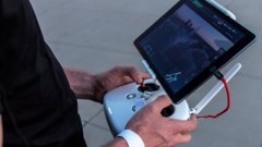
Drones, the Perfect Survival Ally. Ep.4: Signalling for Help
6:28
Learn about some of the advantages and challenges of mapping slums with drones, with a focus on a Rwanda case study.
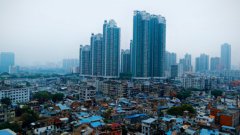
According to the UN definition, slums are areas characterized by people living in vulnerable conditions. They are areas of a city that are overpopulated, that have lack of access to water and decent sanitation, and/or with a very high building density. These areas are often informal, which means that they that there is no legal tenure to be living there.
As cities grow, people come in at a high rate, and there's not enough housing for them. So the poorer population will start building wherever they are able. This is a big problem because it's happening at a very large scale in the low- and middle-income countries. Therefore, international development agendas focus a lot of their efforts on improving the poor living conditions in these areas. The UN estimated that, in 2018, more than 1 billion people, or 23-24% of the urban population lives in slums. Of the Sustainable Development Goals, number 11 is to make cities and human settlements inclusive, safe, resilient and sustainable. Target 11.1 is the proportion of the urban population living in slums.
Because these settlements were formed informally and without official urban planning, it’s not known where infrastructure such as buildings, roads and services are. This makes it difficult for city planners to provide services. If they don’t know how many people are there, it’s difficult to bring water, electricity and waste disposal services into these areas. Mapping is therefore a basic necessity in order to do better urban planning.
When conducting an analysis of an entire city, it’s easier to use a satellite image, as they cover larger areas. When satellites are used for slum mapping it is usually in order to distinguish between which areas are slums and which are not. This is the focus of much of the work being done at the ITC.
Slums tend to be complex environments, with smaller buildings and narrow pathways between them instead of roads. Even with satellites, it can be difficult to identify individual buildings. And the government’s data may not be up-to-date. These aspects point to a key benefit of using drones for slum mapping: the ability to get much more detailed and up-to-date information.
So for a project focussed on upgrading a particular slum, more detailed information and is needed to design the interventions. This is where a drone can really help.
In 2015, the World Bank were working together with the city of Kigali – Rwanda’s capital – on a slum upgrading project. Dr. Caroline Gevaert, who was working on her PhD at the time, went to Rwanda with a drone to see what it could do. What she found was that drones were useful in a number of ways.
Firstly, the drone imagery helped the consultants and government officials who were designing the upgrading project. Having a good overview of the slum helped them plan their fieldwork better. The detailed and up-to-date imagery also gave them a better overview of issues such as solid waste accumulation and erosion in the settlement. They said that having this imagery helped plan more efficiently and design better interventions.
Secondly, the drone facilitated local participation. When an upgrading project is done in a slum, it’s usually necessary – due to the lack of space - to move households in order to make space for the roads and for the new infrastructure. This is delicate process because peoples’ houses are being taken away and moved and the people who are displaced are socially vulnerable. Possessing a detailed drone image therefore helped with the dialogue with slum residents.
In addition, part of the research of Dr. Gevaert was about automating workflows with the use of machine learning and deep learning. In the first instance, showing the drone image to residents had a lot of advantages, as just described. But her research also looked to the added benefit of being able to get maps from the UAV data automatically.
The benefits of using machine learning are on different levels depending on the user. Artificial intelligence methods can speed up the process and, at the city level, this can mean better, more efficient planning. Yet machine learning algorithms can still take some time to set up, and it is important to always have the dialogue with stakeholders on the ground to verify the results.
For Dr. Gevaert, one of the highlights of the participatory upgrading project was how the collected drone images were used. In Kigali, there are different administrative units in the neighbourhoods, and a public ward office building. In this building, the maps had been printed and placed on the walls of the office. When Dr. Gevaert and the other researchers first went to collect the data and wondered what uses the slum residents would make of them, they were frustrated by a lack of ideas.
But, over time, the residents found their own uses for the data. Upon returning to Kigali two years after her initial visit, Dr. Gevaert found that, not only were the maps still on the walls, but they were being put to unexpected uses. One resident who was looking to buy a house wanted to know if there was a road close by as they didn’t want to be moved later. They were able to look at the maps and decide where they wanted to move. The research team were encouraged to see that many different people could use this data for different reasons. This emphasizes the importance of considering how to share data that is collected, e.g. making printed images available to local residents can unlock other uses and benefits.
This article is based on an interview with Dr. Caroline Gevaert. Click here to view the original video entitled 'Mapping Slums with Drones' on the Geo Hero Youtube channel.
Login and start learning!