Planning Support Systems
Layman's Talk: Debbie Oyeku on The Spatial Development Framework
3 min
Participatory mapping is a significant complement to standard mapping and standard GIS. Its driving purpose is to map local people's own knowledge of their own situations, landscapes, or territory. Participatory mapping is intended to be inclusive, so it frequently involves categories of people who are disadvantaged or marginalised, whether by class, wealth, race, indigeneity, or gender.
The basic idea is that ordinary people have a lot of spatial knowledge which planners and outsider experts lack. First and foremost, they have factual knowledge - for example, the residents of a forest-dependent community know well where they get their water, firewood or medicinal plants from and where hazards occur. Such information often cannot be provided by remote sensing. They have to come from people's own experience and knowledge that has accumulated over generations.
Besides the physical factual information, this local spatial knowledge also includes intangible things, like people’s values, interests and priorities. What is significant for communities may be cultural and historical spaces holding sacred, spiritual value. Others may be related to risks and dangers, as with much gendered urban participatory mapping - what urban women feel and know to be more insecure or unpleasant areas. That type of information can only be provided by the people who actually live it.
Participatory mapping became more accepted and widespread in the 1970s and 80s. The standard starting point was a satellite image or aerial photo with a plastic overlay on top of it. Researchers or NGO activists would mark the information gathered from local people on that overlay. Satellite images are much better for this than conventional maps which are full of untruths. At a simple level, a river is not actually a blue line crossing the map sheet, unchanging over the seasons. Even the forests demarcated on the map can turn out to be absent when you visit. Today, Google Earth images are probably the best starting point.
After marking local knowledge onto an image of the area, the team will walk with local people with GPS to visit the sites and geolocate them. What’s the use of this when all that information is already marked on the image? The reason is to double and triple-check and learn more local knowledge. A slow walk with local people can generate additional information not shared at first.
A challenge for participatory mapping is that the knowledge necessarily comes from a small group of involved people. They are often pressed for time when sharing their information, and some individuals can try to dominate the process by stressing just those factors affecting them. In other words, a participation approach is deep, but it's not broad, so the representativeness of the knowledge has to be critically assessed. We should ask ourselves: Who provides the information? Who chooses the providers?
Fortunately, this intensive cross-checking process is strengthened with the use of social media, apps and online platforms. There are new ways of talking to more people and asking them if they agree with the findings from the small initial active group. Participatory mapping processes are greatly benefitting from more ubiquitous and accessible devices such as smartphones, tablets, and UAVs. For information sharing in the field, there are apps such as CyberTracker, GeoODK, & Sapelli. For crowdsourcing and online surveys, there is ArcGIS for LG, Maptionnaire, SeaSketch, & Ushahidi. There are many other softwares - open source or commercial - adaptable to local circumstances. In the final steps of disseminating and using the results of participatory mapping, social media and apps such as OSM, Mapeo, GeoWE, & Onyx, are essential.
Not really! It appears that reading maps is something most people can do without external training. For instance, a colleague at ITC was working in Madagascar with groups of local women. The team was going to instruct these women how to interpret aerial photos. But the women were able to recognize their houses and infrastructure instantly. Something similar happened in Kenya. Elders of an indigenous group, who had previously never worked with aerial photos, identified obscured historical and cultural sites; moreover, they immediately recognized that an aerial photo was missing from the sequence (someone had simply forgotten to bring it).
In most participatory mapping, using GIS adds lots of value. GIS allows spatial analysis, additional pattern recognition, and building geo-information layers. A GIS of a piece of land can have many layers of knowledge - vegetation, water, hazards, and social cultural factors. Local citizens may want certain layers to be secret, such as historic sacred sites. With GIS it is straightforward to block outside people from accessing those layers, and thus protect sites from robbery or desecration. With standard maps, you would have to take away one plastic sheet and hide it.
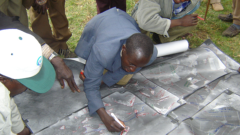
The impact of participatory mapping can be hard to pinpoint, but sometimes it is very clear. For instance, when mapping a forest area in Cameroon, anITC student taught local people how to integrate GIS into their participatory mapping and the community then used the results to claim that forest area from the government. Some years later, the same community was having a dispute with an expanding oil palm plantation and they were able to successfully apply those maps they made in legal proceedings.
At the end of the day, a sustained societal impact is achieved when people use participatory mapping and its inherent data to progress onto other things – hopefully things we haven't even thought of!
This article is based on an interview Dr. Michael McCall, former ITC professor, currently Senior Investigator in the Universidad Nacional Autonoma de México. To view the original video, check out the interview with Dr. McCall on the Geo Hero YouTube channel.
Login and start learning!