Land Administration Systems
Why managing land reform problems works better than trying to solve them
6 min
Land rights mapping, or cadastral mapping, is key to addressing Sustainable Development Goals number 1 set by the United Nations. Of this first goal, target 1.4 refers to equal rights and access to economic resources. This also can be referred to as ‘land tenure for all’.
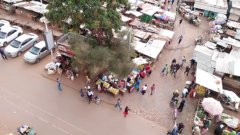
Global estimates indicate that around 70% of the world has not been mapped in terms of cadastre – meaning most people on the planet live in a place without clear ownership. The picture is somewhat better in developed countries, but in places like Africa, a majority of people don't know exactly where are the boundaries of their land.
Aiming to solve this problem, Dr. Mila Koeva and colleagues at the Department of Urban and Regional Planning and Geo-Information Management (PGM) at ITC have sought out faster, easier and more affordable ways to map the land.
In the past, those doing land mapping traditionally used methods such as total station theodolites and GNSS to map every single corner on a property. Using such methods would take years in the African context. So one of the aims of the PGM department is to find innovate methods to speed up this process. Based on the theory of ‘fit for purpose’, researchers have sought to incorporate indirect solutions for this problem – specifically, using image data.
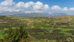
In the beginning, the researchers used satellite images because they cover large areas. However, they found that the resolution of the images is not always enough to see the boundaries; there needs to be clear, visible boundaries on the image so that they can be mapped. That boundary may be a fence or perhaps crops on farm lands if the area is more rural. Urban areas are the most complicated because it’s not always clear – even for experts - where the boundary is on the satellite images.
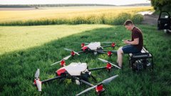
The researchers then switched from satellite to aerial images, with much recent work focussed on drone images. The four-year Horizon 2020 project Its 4 Land – based in Rwanda, Kenya and Ethiopia - aimed at developing innovative solutions in this direction. The project included 8 consortium partners from Europe and Africa, joined with the PGM and Earth Observation Science department (EOS) from ITC.
Switching to drone images, the researchers experienced some challenges, such as finding out the best drones, purchasing them, training the pilots and finding the best photogrammetric settings that would give the optimal result. Following that, the researchers had to design an open-source software or tool that could be easy to operate for users in Africa. All of this took several years. To ensure that these technological developments were responsive to the local needs and easily implementable, the researchers held many discussions with users at the local or governmental level.
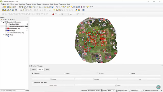
To demonstrate, below is a screenshot of QGIS, an open-source software:
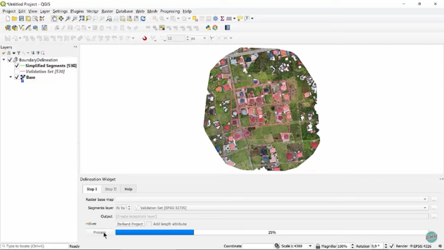
On top of this, the researchers developed a tool that, upon entering an image source of data, allows users to click a button and see the automatically extracted candidate boundaries:
Experts can then zoom in and analyze whether these are the real boundaries that they would like to have in their cadastral data or not and edit them accordingly:
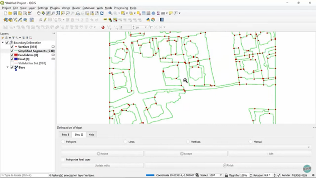
To speed up the manual digitization process, the researchers have developed several additional functionalities for polygon line and polyline editing. This is because there is always need of an expert who has to decide whether a boundary is well-identified or not. It's not possible to fully automate this process.
For the person living on the ground, this process means that the recording of property rights can be done much faster and help them know where the boundaries are. Since the problems is very challenging, this a research line which is in continuous research in the PGM department.
This article is based on an interview with Dr. Mila Koeva on the Geo Hero YouTube channel. Check out the original video of the Geo Hero interview with Dr. Koeva.
Login and start learning!