
Climate Change
Earth from Space: Smoke Plumes from Chile Wildfires
3 min


Can OpenStreetMap support humanitarian efforts by filling data gaps in vulnerable areas?
It’s well-known that vulnerable populations are the most likely to suffer from natural disasters.
This is especially true when violent conflicts force people to seek refuge elsewhere. Such internally displaced persons (IDPs) tend to settle in areas prone to climate-related hazards such as floods, simply because these lands are available, as nobody’s really interested in them.
To make matters worse, over 30% of natural disasters occur in conflict areas. Due to the uncertain and insecure circumstances, systems for disaster risk reduction (DRR), climate change adaptation (CCA), and early warning & early action (EWEA) are often underdeveloped.
This problem is usually exacerbated by a lack of data, especially on exposure and vulnerability.
From this starting point, researchers decided to investigate if and to what extent OpenStreetMap (OSM) could provide a solution. OpenStreetMap is a free, open-source mapping platform built by volunteers.
Can this crowdsourced platform be used to show where to act early, before disaster strikes? In other words, can OpenStreetMap enable better EWEA?
Sudan was selected as the case study country because the Red Crescent had already started an EWEA project there in 2020. Other factors included the compound crisis of climate change and conflict impacting Sudan, and the severe lack of exposure and vulnerability data.
According to several indices, Sudan ranks 15th on the list of countries most vulnerable to climate change and conflict worldwide. In this Northeast African country, climate change is causing floods, droughts, storms, extreme temperatures, and rising sea levels. At the same time, protracted conflict is worsening food insecurity and displacement.
The situation has deteriorated further since April 2023, when new waves of fighting for control of the state and its resources broke out in the capital of Khartoum. As a result, by late 2024, there were over 10.8 million IDPs in the country, many of whom settled in flood-prone areas.
Humanitarian aid efforts in Sudan suffer from limited resources and major data gaps.
In spite of recent improvements, data is still scarce in several crucial areas, particularly geography, infrastructure, health, and education. Sudanese authorities, who are responsible for providing such data, have failed to do so.
A review of geospatial datasets shows that the most recent official data dates back to 2014. Attempts to access more recent data were unsuccessful, as the websites of the responsible authorities were unreachable, and the contact details were inactive.
So how can OSM mapping make a difference here?
Over the past decade, this type of mapping in Sudan has been largely driven by international NGOs and organised mapping initiatives, with a focus on crisis response.
The outbreak of the conflict in April 2023 led to a significant rise in mapping activity, with the number of mapped buildings increasing from 28,300 in 2014 to over 1.4 million by 2024. The resulting increased coverage and availability of recent OSM data have contributed much to the effectiveness of humanitarian response.
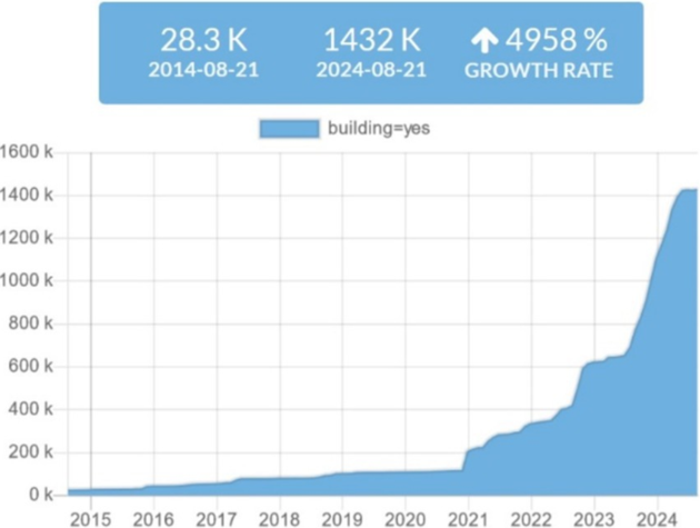
Total number of buildings mapped in OSM across Sudan (source: HeiGIT 2024)
To better understand the needs of people producing and/or using OSM data, the researchers conducted interviews with carefully selected individuals. They were asked to give their views on OSM quality, ethical considerations surrounding the use of OSM data, and their major needs and challenges.
The authors emphasise that the interviews were conducted in 2021, before the escalation of conflict in 2023, which has drastically altered the data landscape. Although the analysis of OSM data was extended to September 2024 to capture these changes, the authors recommend that additional interviews be conducted to reflect the current state of affairs.
According to interviewees, OSM data from trained mappers and validated mapping events is generally accurate. This is confirmed by comparisons with satellite imagery.
However, some aspects are harder to verify due to limited ground access in conflict zones. Conflict also causes rapid changes in the environment, which makes it hard to keep maps up-to-date.
As for OSM data completeness, interviewees noted that the situation in most of the country is most unsatisfactory, especially when compared to key urban areas. This is worrying because incomplete data can lead to misguided crisis response and logistics planning.
Interviewees stated that ethical responsibility primarily lies with OSM data producers. Once data is made public, users will often assume it's ethically sound.
When it comes to inclusion, limited internet access is a problem, and gender imbalance tends to limit female and LGBTQ+ perspectives in mapping initiatives.
Interviewees also expressed concerns about possible military misuse of OSM data.
In terms of needs, user interviewees stressed how vital it is to have complete, up-to-date building and road data, while producers emphasised the importance of knowing the local context and the data’s intended purpose.
To support early warning and response systems, critical infrastructure such as health facilities and schools should be included in OSM maps. This has the added advantage that their location is publicly documented, making “accidental” attacks even less acceptable.
Users as well as producers suggested that incorporating local knowledge could significantly improve the process of producing and using OSM maps.
Based on their research, the authors argue that OSM is a suitable tool to fill crucial geospatial data gaps and enable EWEA in data-scarce areas – and, more specifically, to address the evolving humanitarian challenges in the conflict context in Sudan.
Knowing who’s more likely to be impacted due to vulnerabilities and proximity to hazards can be very helpful to EWEA decision-makers.
Final recommendations include prioritising EWEA efforts in conflict areas and attuning OSM mapping processes accordingly; organising volunteered mapping events to create more crucial OSM mapping data, and making sure ethical considerations are taken into account.
Header image: Maps for free, adapted by Dr. Blofeld, CC BY-SA 2.0 , via Wikimedia Commons
This story is an adaptation of a published journal article: Scholz, C., Jaime, C., Raju, E., Coughlan De Perez, E., & van Aalst, M. (2024). Off the grid: utilizing OpenStreetMap for early warning and early action in conflict settings in Sudan. Frontiers in Climate, 6, 1439940. It has been adapted with permission from the authors and in accordance with the copyright license CC BY 4.0
To read the original paper, follow the link below:
Login and start learning!