UAV
Building Your Own Farm-Tech? Start Here
3:14
A new study examined the role of drones in monitoring air quality. In this story, we'll explain how they work and some of their advantages.
Unmanned aerial systems (UAS), commonly known as drones, have revolutionised remote sensing applications. One such application is air quality monitoring. The capabilities of drones make them invaluable for mapping air pollution, especially in challenging or hazardous environments.
Unlike traditional platforms, drones offer high-resolution data collection, cost efficiency, and operational safety, enabling novel applications and research directions.
Modern drones integrate a variety of sensors for precise air quality monitoring, including:
- Imaging Sensors: Visible-light, multispectral, hyperspectral, and thermal-infrared sensors.
- Active Sensors: LiDAR and geophysical instruments like magnetometers and ground-penetrating radars.
- Air Pollution Sensors: Lightweight, miniaturised instruments designed for UAV platforms.
These sensors enable drones to generate 3D air quality maps and analyse pollutants in real time. The data is often processed in cloud-based systems, ensuring scalability and accessibility for further analysis.
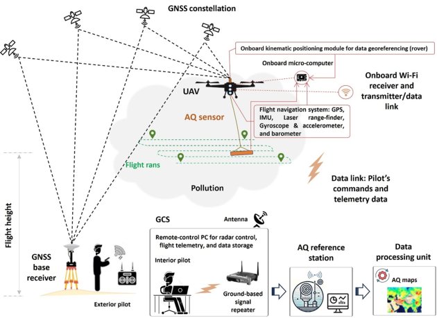
A UAS includes four key components:
- Aerial Platform: The drone itself, ranging from fixed-wing (for wide-area mapping) to rotary-wing designs (ideal for maneuverability in confined spaces).
- Ground Control Station (GCS): Used for mission planning and manual operation.
- Communication System: Facilitates data exchange via wireless methods.
- Navigation System: Relies on Global Navigation Satellite System (GNSS) with advanced modes like real-time kinematics (RTK) for precision.
Fixed-wing drones are preferred for large-scale surveys due to their long flight durations, while rotary-wing drones excel in areas requiring agility and low-altitude sampling.
Emerging platforms, such as tethered airships and remotely controlled balloons, offer alternative solutions for specialised applications.
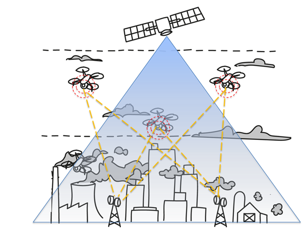
UAV-borne remote sensing of air pollution. Image: Javan et al. (2025)
In our recent paper, we studied the application of drones for air quality monitoring. The review revealed that recent trends in sensing technology show a strong preference for PM (particulate matter) sensors and gas analysers. This reflects a balance between measurement accuracy and operational feasibility in field conditions.
Most studies target PM pollutants and common gases such as Carbon Monoxide (CO), Carbon Dioxide (CO2), Nitrogen Dioxide (N02) and Nitrogen Oxides (N0x), underscoring a focus on urban air quality concerns.
However, the limited use of advanced instruments, such as mass spectrometers, and the insufficient coverage of Volatile Organic Compounds (VOCs) and other specialised pollutants, indicate a technological gap.
Future research should prioritise the development of compatible, lightweight sensors to address this shortfall.
Drone deployment for air quality monitoring is subject to regulatory constraints that vary by region.
While their small payload capacity limits sophisticated instrumentation, drones compensate with affordability, autonomy, and safety—especially in hazardous or inaccessible locations like volcanic zones or nuclear sites.
The development of compact, high-performance sensors and the refinement of UAV navigation systems are crucial for addressing current limitations.
Additionally, harmonising international drone regulations can unlock their full potential for global air quality monitoring.
By bridging technological innovation with operational practicality, drones are setting a new standard in air quality monitoring.
With advancements in sensing technology and a focus on addressing critical pollutant gaps, drones enable precise, efficient, and safe pollution mapping, paving the way for sustainable environmental management.
This story is an adaptation of a journal article: Javan, F. D., Samadzadegan, F., & Toosi, A. (2025). Air pollution observation—bridging spaceborne to unmanned airborne remote sensing: a systematic review and meta-analysis. Air Quality, Atmosphere & Health, 1-69. It has been adapted with permission from the authors and in accordance with the copyright license CC BY 4.0
To view the original article, follow the link below:
Login and start learning!