
Artificial Intelligence
Can Artificial Intelligence Save the Amazon Rainforest?
3:19


A recent study proposed a powerful method to detect unorganised, small-scale mining using freely available satellite data and open-source platforms and tools.
Parts of the Amazon Rainforest are being threatened by gold mining in artisanal small-scale mines (ASMs). Besides causing forest loss, this type of mining involves removing topsoil or dragging out the sediments from river bottoms. This causes erosion and damages ecosystems.
Stirring up river bottoms can also release dangerous substances like mercury (used to amalgamate gold), which harm water quality and aquatic life.
Countering these impacts requires efficient detection and monitoring of ASM activity, which will enable interventions by policymakers.
ASMs are difficult to map from space. They’re small, irregularly shaped, unevenly distributed, have restricted accessibility and are easily mistaken for other land clearance types.
To remedy this, researchers developed a novel ASM detection method that was put to the test in Pará state, a traditional gold mining region in the Brazilian part of the Amazon Rainforest. In Pará state, ASM activity has significantly altered the landscape ever since the first major gold rush that began in 1958.
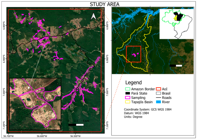
Study area: the Pará state and Tapajos River basin, Brazil. Image: Fonseca et al. (2024)
The researchers acquired the necessary geospatial time-series data by accessing Landsat satellite images from 2000 to 2019.
To build a classification model capable of capturing the complex and varied spatial patterns found in ASM areas, they used several typical spectral vegetation indices (cover and changes over time) and textural features (used to characterise the spatial structure of the landscape and extract spatial patterns and relationships from imagery).
The data was then processed using an algorithm called LandTrendr (Landsat-based Detection of Trends in Disturbance and Recovery) in Google Earth Engine. LandTrendr helps to analyse changes in land cover over time, through a temporal segmentation designed to extract and analyse spectral trajectories of land surface change from yearly image time-series.
In the next step, a Random Forest (RF)* machine learning ASM detection model was trained using the information generated by LandTrendr, supplemented by ancillary data such as proximity and topographic. The method was validated using ASM areas identified from field surveys and high-resolution images.
The results of the study show that the proposed method is suitable for reliably mapping ASMs with high accuracy at moderate (30-metre) resolution. Important findings include the fact that large and widespread increases in ASM-driven natural vegetation disturbance in the study area were observed following the global financial crisis of 2008.
Furthermore, the most important feature in ASM detection turned out to be NDVI (Normalized Difference Vegetation Index), an index that is effective at identifying vegetative from non-vegetative surfaces. Researchers found that the performance of the RF model was boosted by textural features in the near and shortwave infrared range of the electromagnetic spectrum. The most important textural features for ASM detection were variance, prominence, shade, and contrast.
The overall accuracy of the final Random Forest model classification was 92.6%, which is comparable to studies mapping large industrial mines. This is an impressive score, especially considering the small scale of ASMs and the “mixed pixel effect”. Unlike pure pixels that contain only one type of land cover, mixed pixels contain information about multiple distinct objects or land cover types within a single pixel unit in an image, making it hard to accurately identify what’s actually on the ground.
The researchers expect their work to pave the way for future ASM monitoring through large-area monitoring from space. Accurate and efficient detection of ASMs can help government agencies, non-governmental organisations and other decision-making bodies to better protect the environment by intervening where necessary. It can also enhance regulatory enforcement in such a way that restricts the illegal exploitation of natural resources.
As ASM activity often causes health risks from exposure to toxic substances as well as safety hazards from unstable mining structures, restricting it would also be beneficial in terms of community health and safety.
Finally, rigorous ASM detection could help to reduce human rights abuses such as forced labour, child labour and exploitation, and prevent conflicts and societal instability that are often associated with artisanal small-scale mining.
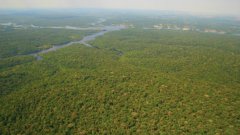
Header image: James Martins, CC BY 3.0, via Wikimedia Commons
This story is an adaptation of a journal article: Fonseca, A., Marshall, M. T., & Salama, S. (2024). Enhanced detection of artisanal small-scale mining with spectral and textural segmentation of Landsat time series. Remote Sensing, 16(10), 1749. It has been adapted with permission from the authors and in accordance with the copyright license CC BY 4.0
To view the original article, follow the link below:
Login and start learning!
