Planning Support Systems
The EquiCity Game: Promoting fair decision-making in urban planning
6 min
Urbanization can be a positive force for the development of countries, in both urban and rural areas. But there may be problems in terms of regional development if people and resources are not well distributed. A booming town will soon get in trouble if it lacks skilled people or certain types of facilities, buildings and infrastructure. Similarly, less developed (or more remote) settlements can be at risk of being “left behind”.
Within settlements, everything is interconnected. Factories provide jobs while depending on electricity, skilled workers and loans from banks. The families of those workers need access to school buildings with teachers, and to health care centres with doctors. In short, settlements require a balanced mix of functions that work together and support each other.
Unfortunately, it often happens that a certain essential function – or even a combination of functions – is lacking. If this is the case, problems can arise. For instance, a school that doesn’t have access to water and electricity won’t perform as well as a school that does. Preventing these types of issues calls for a complete picture of opportunities and shortcomings for all settlements.
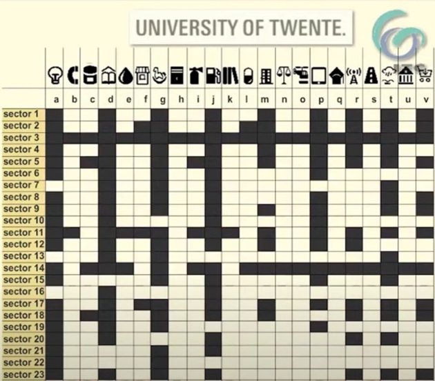
Generating such a picture requires a lot of information from experts in all relevant fields. But information alone is not enough. What matters is how all those different bits of information are connected. A shared and factual understanding of that complicated framework is needed to enable efficient spatial planning. The overview for all settlements in a country – from big cities to smaller towns – can be obtained by making an inventory of the functions in all settlements and then collecting those functions in a Matrix of Functions.

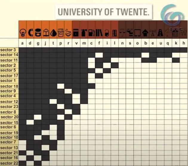
From this Matrix of Functions, a hierarchy of settlements can be derived.

Sorting the most frequent functions to the left and settlements with the most functions to the top allows for identifying the following:
• groups of basic functions that almost all settlements have
• intermediate functions that the bigger settlements have
• central functions that only a few settlements have.
The hierarchical network of settlements can be shown by mapping the hierarchy, and thus find local, intermediate and central urban centres.
The matrix of functions provides valuable insights that enable urban planners to empirically establish what the basic, intermediate and central functions are – not as wishes but as reality. They can identify gaps in columns and conclude whether a single function is well distributed over the territory. Gaps in rows help them to identify whether a single settlement has all the functions it needs. Finally, they can plan for action to make municipalities move from basic to intermediate level, or from intermediate to central level
As a result, plans can be made to get functions in the right places and put the resources of the country to good use. Experts can communicate about the territory and get maximum insight with easily available data. The matrix of functions is therefore an ideal foundation for creating effective development scenarios for urbanization.