Digital Twins
Cities are Cloned in the Virtual World to Transform Urban Planning
4 min
Digital twins can be useful in many ways; they can help to solve many societal challenges and problems, especially when there is a strong geo-visualization and geospatial component involved.
The term “Digital Twin” was first used in manufacturing. Nowadays it also finds its place in many other domains, such as city planning. As defined by the Digital Twin Geohub of University of Twente, Digital Twins (DTs) can be seen as digital replicas of the physical living environments that support decision-making through the seamless integration of a myriad of data and analytics techniques. As such, a DT is not a mere geometric (2D and 3D) representation of static assets, but a dynamic/live model that represents their past, current, and future states.
DTs are composite computational models consisting of data models and simulation models that provide the means for the replication of spatial dynamics of multiple environmental phenomena in cities (and beyond). as well as They allow for the assessment and analysis of the interaction of natural and anthropogenichuman-caused factors that bring about these spatial dynamics. As such, DTs provide an evidence-based foundation for supporting decision-making processes and augmenting them with the power of computational simulations and artificial intelligence. They allow us to assess the environmental, social and economic impacts of urban planning processes and decisions.
The United Nations’ Sustainable Development Goal (SDG) #11 is to “make cities and human settlements inclusive, safe, resilient and sustainable”. In achieving this, digital twins (DTs) may have an important part to play.
City planners can use city digital twins to simulate and evaluate various scenarios, as a basis for making informed decisions about infrastructure, transportationtransportation, and public services. By combining computer simulations and artificial intelligence (AI), DTs help assess the environmental, social, and economic impacts of planning decisions. The idea is to use technology to make urban planning smarter, aiming to achieve Sustainable Development Goals and fortify our communities against evolving conditions, needs, and risks. In simpler terms, it's about using cutting-edge tools to make our cities more resilient and sustainable. In line with the United Nations' Sustainable Development Goal 11, which focuses on creating sustainable cities and human settlements, there's a push for better land use, water management, sanitation, drainage, and waste disposal.
The emphasis is on creating environmentally friendly infrastructure. Given the current climate challenges, cities worldwide need to rethink how they design spaces and structures. By combining computer simulations and artificial intelligence (AI), DTs help assess the environmental, social, and economic impacts of planning decisions. The idea is to use technology to make urban planning smarter, aiming to achieve Sustainable Development Goals and fortify our communities against evolving conditions, needs, and risks. In simpler terms, it's about using cutting-edge tools to make our cities more resilient and sustainable.
DTs are used to manage infrastructures (e.g., roads, transportation, energy, and water networks), support planning and decision making, as well as to provide up-to-date data for simulations. Digital Twinning as a scientific and technological endeavour is about making geospatial and simulation models and their integration for two major reciprocal tasks in planning processes: policy analysis and environmental assessment. Environmental assessment typically focuses on factors such as air and water quality, biodiversity, land use, and socio-economic effects, aiming to inform decision-making processes and ensure sustainable development on a very large scale. Conversely, policy analysis involves the use of these factors to examine specific, tangible impacts of policies on a smaller scale.
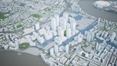
Revolutionizing city planning, theseThese dynamic replicas have revolutionized in city planning and are the architects of tomorrow's metropolises, enabling precise 3D visualization of rapidly expanding urban landscapes. From optimizing transportation networks to managing energy grids, water systems, and waste disposal with unprecedented efficiency, City Digital Twins pave the way for sustainable urban living.
To read more about where digital twins have been successfully deployed, check out our article onshowing 3 examples of successful city digital twin applications.
The scalability of digital twins is dynamic; they are adaptable to diverse contexts and applications. At a micro-level, digital twins can mirror specific devices or components, while at a macro-level, they can encapsulate comprehensive systems or urban landscapes.
While digital twins can effectively represent individual objects, systems, or even entire cities, the scalability depends on a number of factors, such as computational resources, data complexity, and modelling intricacy.
Technological advancements, particularly in cloud computing and data processing, continuously push the boundaries of scalability. Although there isn't a hard limit, practical considerations require a thoughtful balance between the desired level of detail and the computational resources available. This ensures that digital twins remain versatile tools across a spectrum of scales and applications.
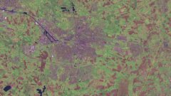
There are many methods for building a digital twin. For researchers at the UT’s Faculty of Geo-information Science and Earth Observation (ITC), the starting point is always raster or point cloud data obtained from sensors mounted on variety of platforms. These can be satellite images or aerial acquisition data from aeroplanes or unmanned aerial vehicles (UAVs) or LiDAR data. The power of Digtal Twins is in combination of variety of data sources. Therefore, existing maps, GIS vector data of the area and the obligatory sensor information monitoring in real time the environment (e.g. for temperature, air quality, noise, traffic etc.) are always needed. the sensors available for the area that a model is planned for. Researchers start by searching available maps and satellite images or aerial acquisition data from aeroplanes or unmanned aerial vehicles (UAVs). Sources can include image data, point cloud data from Lidar acquisition, or terrestrial laser scanning.
With the data in hand, researchers then have to ask what kind of processes can be run on that data. They explore whether they can use automation by using machine learning or deep learning algorithms for data analysis or to speed up the extraction of features or objects out of the data. They also investigate the possibility of collaborating with civil engineers working on building information modelling in order to build extra detailed models that are labelled as “intelligent” models.
In the next step, University of Twente researchers are aiming at usage of open-source solutions are used tofor developing city the digital twins. They start with user requirements and stakeholder analysis and involve them during the process of the tool development. In that way the users are being trained in using but also updating the digital twin models themselves.
and give stakeholders the best possible access to them. Ideally, stakeholders themselves are also involved in the creation phase, and are given tools to update and maintain their digital twins autonomously.
To learn more, see our article on Building a city digital twin: needs and challenges.
In the 3D city modelling domain there are many challenges. Starting from data formats, quality, intermobility, standardisation and finishing with data publishing and exchange. Trying to overcome these challenges the researchers from UT are aiming to reach even higher complexity by integrating real time data and using AI for its analysis and processing. One of the successful example is related to the integration of 3D data of the overground and underground leading to a digital twin solutions that help decision makers in predicting and influencing the reality based on the simulations done in the digital environment.
Up until now, 3D city models have up until now been created in quite a static way, and in many countries there has been a lack of synchronization between different municipality departments or ministries. The UT is trying to take these kinds of 3D models one step further by integrating more and different types of data, from both overground and underground. ; Bby synchronising the models and making them more dynamic, the aim is to in order to reflect the changes that cities undergo every day.
For the UT, the primary aim is to be able to update the developed city digital twin models or at least develop algorithms that can keep them up to date, and to share them in a more user-friendly way with the users and stakeholders for fair decision-making processes.
Login and start learning!